Good morning. This is Alex Marienthal with the Gallatin National Forest Avalanche Forecast on Monday, December 12th at 7:00 a.m. This information is sponsored by Yellowstone Club Community Foundation and Avalanche Alliance. This forecast does not apply to operating ski areas.
Please consider donating to the Friends of GNFAC Annual Fundraiser.
Since yesterday morning the mountains received 2-3” of snow from Big Sky to West Yellowstone, 1” near Cooke City, and zero elsewhere. This morning, light snow is falling, temperatures are teens to mid-20s F, and wind is southeast-east at 5-15 mph. In the Bridger Range, east wind is 20 mph with gusts to 35 mph. Today temperatures will be teens to low 20s F with east-northeast wind at 5-20 mph. Light snowfall will continue in most areas with 2-5” possible by tomorrow morning.

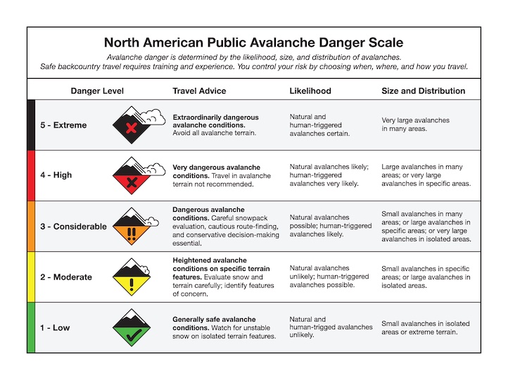
A person can trigger a large avalanche that breaks on weak layers buried 2-3 feet deep, or deeper on heavily wind-loaded slopes. Minimal new snow and light winds are giving the snowpack a break from added weight, and the likelihood of triggering a large avalanche has decreased. However, the consequences remain large and potentially deadly. These avalanches can be triggered from low angle terrain below steep slopes, and can be triggered by the second, third, or tenth person on a slope.
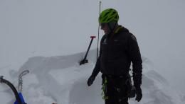
Natural and human-triggered avalanches that occurred over the last couple weeks near West Yellowstone and Cooke City are examples of what is possible (Lionhead avalanche video, Daisy Pass video, Henderson photo and details). On Friday, my partner and I triggered an avalanche that broke 3-6 ft deep and 500 feet above us while we were crossing below a steep slope near Lulu Pass north of Cooke City (video, photo). The snowpack was less than 3 feet deep where we triggered the avalanche from, but the fracture extended up to the deeper, heavily wind-loaded ridgeline.
Snowpack stability assessment for these large avalanches is tricky. Keep a wide margin for error and avoid travel on and underneath steep slopes that you suspect have a buried weak layer, especially slopes that are heavily loaded with wind-drifted snow. Today, large human-triggered avalanches are possible and avalanche danger is MODERATE.
Over the past week, strong south-southwest wind blew new snow into dense drifts that can avalanche under the weight of a person on steep slopes (Buck Ridge wind slab, Bridger Range wind slabs, Mt. Blackmore wind slab). Yesterday I looked at the snowpack on Saddle Peak in the Bridger Range and found these hard wind slabs are still possible to trigger (Saddle Peak video), and deeper avalanches will become possible when there is snow and wind-loading. Although recently formed wind slabs are relatively shallow (6-10”), they could propagate wide and are especially hazardous if they push you into trees, rocks or over a cliff. Doug was ice-climbing in Hyalite on Friday and found a 10” deep drift sitting over a thin weak layer (Hyalite gullies video). A setup like this makes wind slabs possible to trigger for many days after they form. Before crossing or riding steep slopes, carefully assess the snowpack for slabs resting over weak layers and consider the consequences of even a small slide. The avalanche danger is MODERATE.
If you get out, please share avalanche, snowpack or weather observations via our website, email (mtavalanche@gmail.com), phone (406-587-6984), or Instagram (#gnfacobs).

Recent new snow and strong winds make avalanches possible for a person to trigger today. Last Friday, Dave and Ian found up to 18” of new snow while riding in Yale Creek and drifts up to 4 ft deep (field video). They also found weak layers similar to what we’ve seen in Lionhead (field observations). Be extra cautious of steep slopes, especially slopes that are wind-loaded.
Upcoming Avalanche Education and Events
Our education calendar is full of awareness lectures and field courses. Check it out: Events and Education Calendar.
TONIGHT!!!, December 12, 5-8 p.m. @MAP Brewing, Movie Night.
Tuesday, December 13, 6 p.m., Avalanche Awareness + Beacons at Story Mill Park. Free.
Watch our playlist of YouTube videos to get caught up on our avalanche concerns this season.