Good morning. This is Dave Zinn with the Gallatin National Forest Avalanche Forecast on Tuesday, December 20th at 7:00 a.m. This information is sponsored by the Yellowstone Club Community Foundation and Mystery Ranch. This forecast does not apply to operating ski areas.
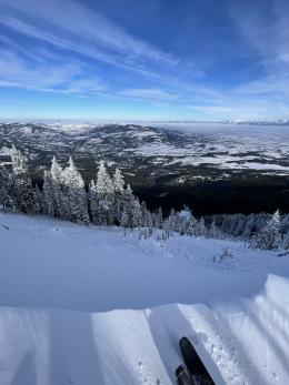
This morning, temperatures are in the single digits to mid-teens F with 15-25 mph winds from the west to the southwest. In the last 24 hours, the mountains near Cooke City received 6” of snow with 2-4” in the mountains from the Taylor Fork through Lionhead Ridge. Today, temperatures will reach the upper teens F with 10-20 mph wind from the southwest. Snowfall will intensify overnight, bringing 8-10” of snow near Cooke City, 6-8” near West Yellowstone and 2-4” to the mountains near Big Sky and Bozeman by morning.

Continued snowfall combined with wind-loading and persistent weak layers buried 2-4’ deep add up to heightened avalanche danger in the southern portions of the advisory area. Dangerous avalanche conditions will develop if today’s snowfall arrives early or with greater intensity than forecast.
Small avalanches within the new and wind-drifted snow are the most likely event. However, large, human-triggered and natural avalanches breaking 2-5’ deep have accompanied significant storms this season (avalanche activity list). Periods of incremental loading (a little snow yesterday, a little snow today) are times when we can get a nasty surprise. Like the frog in slowly warming water, we must jump out before things get too hot.
Avoid wind-loaded slopes and carefully assess for the presence of deeply buried weak layers before considering playing on or underneath steep slopes.
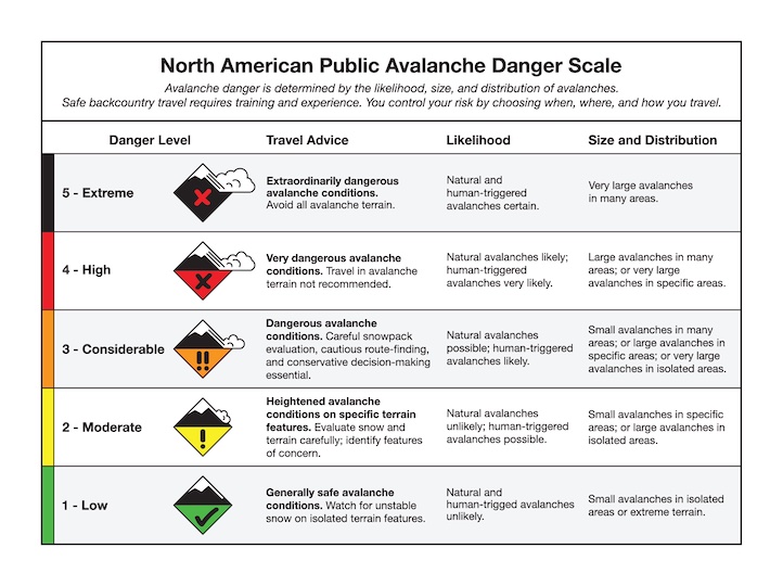
Because large, human-triggered avalanches are possible, the danger is rated MODERATE. The danger will rise to CONSIDERABLE in wind-loaded terrain if daytime snowfall exceeds the forecasted amounts.
In the northern portions of the advisory area, human-triggered avalanches breaking on slopes with recent drifts of snow are possible. This weekend, natural and human-triggered slides generally failing 1-2 feet deep indicate this potential instability (Weather and Avalanche Log). A skier caught and carried by a slide on Saddle Peak on Friday is a good reminder of the danger of wind-loaded slopes (details and photo). While the likelihood of triggering an avalanche has decreased since this weekend, the danger has not.
The lower snowpack in the mountains around Bozeman and Big Sky has weakened. We do not have a widespread problem in which we expect avalanches to fail deep in the snowpack yet, but have it on your radar. Dig down to assess and test the layer of sugary facets buried 1-3 feet deep, and let us know what you find by submitting an observation. Yesterday, a pair of skiers near Divide Peak in the Northern Gallatin Range found propagation in their extended column test, an unstable result (observation). Watch our recent videos from Beehive Basin, the Throne, Buck Ridge and Mount Ellis for more information.
Today, be cautious on or near recently wind-loaded slopes and test weak layers buried 1-3 feet deep for potential instability. Expect the danger to rise if tonight’s snowfall arrives earlier and with greater intensity than forecast. The avalanche danger is MODERATE.
If you get out, please share avalanche, snowpack or weather observations via our website, email (mtavalanche@gmail.com), phone (406-587-6984), or Instagram (#gnfacobs).

Snowfall combined with wind-loading and persistent weak layers buried 2-4’ deep in the snowpack add up to heightened avalanche danger in the Centennial Mountains of Island Park. The danger will increase if daytime snowfall amounts exceed forecasted amounts. Avoid wind-loaded slopes and carefully assess for the presence of deeply buried weak layers before considering playing on or under steep slopes.
Upcoming Avalanche Education and Events
Our education calendar is full of awareness lectures and field courses. Check it out: Events and Education Calendar.
January 4 + field day on January 7 or 8, Avalanche Fundamentals for Snowmobilers, Information and pre-registration HERE.
January 4 + field day, Avalanche Fundamentals for Skiers and Snowboarders, Information and pre-registration HERE.
Every Saturday, 10 a.m - 2:00 p.m. Avalanche Rescue Training, drop in for any amount of time. Round Lake Warming Hut, Cooke City. Free.
Please consider donating to the Friends of GNFAC Annual Fundraiser.
Send us your observations. They do not have to be fancy, just a few sentences. Did you see any avalanches? How much new snow? Is the wind blowing and drifting snow? Pictures, snowpits and stability test scores are also welcome, but not necessary. You can help us fill in the gaps of our field work.