Good morning. This is Doug Chabot with the Gallatin National Forest Avalanche Forecast on Wednesday, December 28th at 7:00 a.m. This information is sponsored by Highline Partners and onX. This forecast does not apply to operating ski areas.
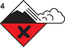
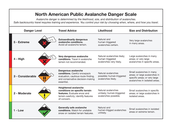
We are issuing a Backcountry AVALANCHE WARNING for the Lionhead Area in West Yellowstone and Centennial Mountains in Island Park, ID. One to two feet of heavy, dense snow and very strong winds have created very dangerous avalanche conditions for today. Natural and human triggered avalanches are likely. Avalanche terrain and avalanche runout zones should be avoided. The avalanche danger is rated HIGH on all slopes.
This warning will expire or be updated by 6:00 a.m. on Thursday, December 29, 2022.
We had crazy weather in the last 24 hours: rain and snow in the northern mountains, snow in the south and winds hitting 105 mph on Lone Peak. 2-3” of dense snow fell around Bozeman and Big Sky and 6-9” fell near West Yellowstone and Cooke City. Wind was W-SW and blew 40-80 mph in most areas yesterday and lessened to 20-40 mph this morning. Mountain temperatures are in the 20s. Today the mountains will get 1-2” of snow, below freezing temperatures and W-SW wind at 15-30 mph.
Avalanche Warning
The Lionhead and Island Park mountains have dangerous avalanche conditions. 6-9” of heavy, wet, dense snow at SNOTEL sites equaled 1.2”-1.6” of snow water equivalent (SWE). Trust me…this is a lot of weight. There is a weak layer of sugary, faceted snow about 1-2 feet under the surface which will avalanche. Our video from Lionhead and this photo show the problem causing this warning. Stay away from avalanche terrain. This includes underneath steep slopes and drainage bottoms which are terrain traps. For today, the avalanche danger is rated HIGH on all slopes.
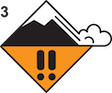
The southern Madison Range, southern Gallatin Range and mountains around Cooke City all received 4-6” of snow equaling 1.1” of SWE with very strong SW wind gusting to 60 mph. This snow fell onto a snowpack with a known weak layer of sugary facets buried 1-2 feet under the surface. This layer is not everywhere, but the avalanche potential will be elevated on slopes harboring it. Dave and I found it in Bacon Rind yesterday and on one slope it was remarkably unstable (observation and video). In Cooke City a snowboarder triggered a slide on Monday (observation and photos), and a skier found this weak layer south of town on 2 occasions (observation). Another weak layer of faceted snow is near the ground which warrants caution because any slide breaking this deep will be large. Given yesterday’s new, dense snow and strong wind, it’s a good idea to not get into avalanche terrain. Be especially careful at the bottom of slopes because these areas seem safe, but are not. Avalanches can be triggered low on a slope when the weak layer is connected to higher elevations. For today, the avalanche danger is rated CONSIDERABLE on all slopes since human triggered avalanches are likely.

Rain, dense snow and strong wind plagued the mountains around Bozeman and Big Sky yesterday. 2-3” of new snow equaled .4-.6” of SWE, or 20% snow density, which gave the snow a cream cheese consistency. These mountains have 2 weak layers of sugary, faceted snow on many, but not all slopes. These can be found 1-foot under the surface and the bottom third of the snowpack. New snow, especially on wind-loaded slopes, is keeping the possibility of triggering avalanches alive. On Monday, a skier triggered a collapse or “whumpf” of the snowpack near Big Sky (observation), Dave found weak snow on Mt. Blackmore (video), and Alex also found weak layers and recent avalanches on Buck Ridge (video). The only way to know if these weak layers are present is to dig and assess. For today, the avalanche danger is rated MODERATE on all slopes.
Please share avalanche, snowpack or weather observations via our website, email (mtavalanche@gmail.com), phone (406-587-6984), or Instagram (#gnfacobs).
Upcoming Avalanche Education and Events
Our education calendar is full of awareness lectures and field courses. Check it out: Events and Education Calendar.
TOMORROW, December 29, 6:30 p.m., Avalanche Presentation and Raffle (great odds of winning!) at MAP Brewing in Bozeman. Free.
January 4 + field day on January 7 or 8, Avalanche Fundamentals for Snowmobilers, Information and pre-registration HERE.
January 4 + field day, Avalanche Fundamentals for Skiers and Snowboarders, Information and pre-registration HERE.
Every Saturday, 10 a.m. - 2:00 p.m. Avalanche Rescue Training, drop in for any amount of time. Round Lake Warming Hut, Cooke City. Free.
Loss in the Outdoors, for those who have been affected by grief and loss related to outdoor pursuits.Check out the link for more information.
Please consider donating to the Friends of GNFAC Annual Fundraiser.
A Beacon Checker was installed by the Hebgen District FS snow rangers at the trailhead to Denny Creek and Lionhead Ridge. It was made possible by the family of Bradie Becker in partnership with The Friends of GNFAC.