Good morning. This is Doug Chabot with the Gallatin National Forest Avalanche Forecast on Wednesday, February 8th at 7:15 a.m. This information is sponsored by Uphill Pursuits and Highline Partners. This forecast does not apply to operating ski areas.
At 6 a.m. Lionhead received an inch of snow overnight and snow is just beginning to fall. Wind has increased from the west to southwest averaging 20-30 mph with gusts of 50 mph. Temperatures are in the teens and will climb into the high 20s today. Wind will remain strong all day and by late afternoon the mountains should have 2-4” of new snow.
The Bridger, Gallatin and Madison Ranges and Lionhead area, have another day of strong wind with a few inches of new snow falling. West to southwest wind is averaging 15-30 mph and gusting to 50 mph. Yesterday, as the snow was actively loading, I was able to intentionally trigger a slide in Island Park near West Yellowstone (info and video), sledders triggered a slide on Two Top (info), and drivers saw road cuts avalanching in Bridger Canyon (photos). If it is snowing and blowing, triggering avalanches gets easier. Recent avalanche activity and shooting cracks, like I got yesterday (photo), are a clear sign that slopes are unstable and should be avoided.
The mountains have weak layers of sugary snow in the top 2-3 feet of the snowpack that are reactive in stability tests. We have seen these layers in the Throne of the Bridger Range, in Hyalite, Mt. Wheeler, Beehive Basin, and near West Yellowstone. A skier triggered a large slide on a north facing slope on Hyalite Peak on Saturday (observation and pics), a sledder noted a slide on Sage Peak that slid on Monday.
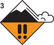
Stay off of wind-loaded terrain and be wary of buried weak layers since they can still avalanche on a few slopes. Triggering avalanches on wind-loaded terrain is likely and the danger is rated CONSIDERABLE on these slopes. On slopes without a wind-load, the danger is rated MODERATE.
The mountains around Cooke City received 9” of snow Monday and Tuesday with very little wind, but that has changed. Wind gusts are in the mid 30’s and recent snow is getting blown into drifts. Wind is not confined to the ridgetops (it rarely is around Cooke City) and fresh wind-drifts will easily be triggered. These mountains also have a new weak layer of sugary facets about 1-2 feet under the surface which Alex forewarns us about (video). In general, today is a day to avoid slopes that have been wind-loaded. Near Sheep Mountain on Monday, riders triggered a small slide on one of these weak layers (photo and details). There is no free lunch: you have to dig, look for weak layers and avoid steep slopes as soon as you find instability.
For today, the avalanche danger is rated CONSIDERABLE on all wind-loaded slopes and MODERATE on all others.
Please share avalanche, snowpack or weather observations via our website, email (mtavalanche@gmail.com), phone (406-587-6984), or Instagram (#gnfacobs).

The mountains have another day of strong wind with a few inches of new snow falling today. If it is snowing and blowing, triggering avalanches gets easier. Yesterday, as the snow was actively loading, I was able to intentionally trigger a slide in Island Park near West Yellowstone (info and video) and sledders triggered a slide on Two Top (info). Stay off of wind-loaded terrain and be wary of buried weak layers since they can still avalanche on a few slopes. Triggering avalanches on wind-loaded terrain is likely today.
Upcoming Avalanche Education and Events
Our education calendar is full of awareness lectures and field courses. Check it out: Events and Education Calendar.
TOMORROW, February 9, FREE Avalanche Awareness at REI Bozeman. More details to come.
February 11, 10 a.m.-2p.m. Companion Rescue Clinic Field Day in the Bozeman area. Required Online Classroom Session at 6 p.m. on Feb 10. Information and course registration are HERE.
February 16, FREE Avalanche Awareness night for women at REI Bozeman. Time TBD.
March 3-5, Bozeman Splitfest. More info and register here.
Every Saturday, 10 a.m. - 2:00 p.m. Avalanche Rescue Training, drop in for any amount of time. Round Lake Warming Hut, Cooke City. Free.
Loss in the Outdoors, is a support group for those who have been affected by grief and loss related to outdoor pursuits. Check out the link for more information.
Bruce Jamieson’s videos on Snow Science explain heady topics to the layman. Understanding the avalanche dragon helps keep us alive.