Good morning. This is Alex Marienthal with the Gallatin National Forest Avalanche Forecast on Saturday, March 4th at 7:00 a.m. This information is sponsored by Knoff Group Real Estate, Upper Yellowstone Snowmobile Club and Bozeman Splitfest. This forecast does not apply to operating ski areas.
Since yesterday morning the mountains near Bozeman and Big Sky received 3-6” of low density snow, and near Cooke City and West Yellowstone received 1-2”. This morning, temperatures range from zero to low teens F, and wind is out of the southwest at 10-15 mph with gusts of 20-30 mph. Today temperatures will reach low 20s F with south-southwest wind at 10-30 mph. Snow showers could deliver 1-3” by this afternoon near Cooke City and West Yellowstone, and by morning an additional 2-3” is possible throughout the forecast area. More snow is expected tomorrow.
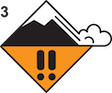
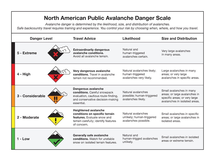
Dangerous avalanche conditions exist near Cooke City. Human-triggered avalanches are likely which could break 3-6 feet deep. On Thursday near Daisy Pass, skiers triggered a large avalanche that buried their snowmobile parked on the groomed trail below and barely missed a group of riders that had just passed by (photos and details). Yesterday a snowmobiler triggered a thick slab of wind-drifted snow on a small slope (photo). Over the last two weeks, this area received snow every day except one, and moderate to strong winds drifted snow into thick, heavy slabs. There have been many large natural avalanches, the most recent on Tuesday (photo, photo), and three human-triggered avalanches last weekend resulted in partial burials and luckily nothing worse (Town Hill, Round Lake, Mt. Abundance). There are various buried weak layers, and recent avalanche activity is enough evidence to show the snowpack has been pushed to its breaking point. Today, cautious route finding and conservative decision making are essential. Avoid riding on slopes steeper than 30 degrees, especially if they are wind-loaded, and be extra cautious crossing below steep slopes. Avalanche danger is CONSIDERABLE.

From Big Sky to West Yellowstone there are buried weak layers that make it possible for a person to trigger a large avalanche. Yesterday on Buck Ridge, riders triggered an avalanche a few feet deep that looks like it broke on an older buried weak layer (photo). Earlier in the week, a snowmobiler triggered a similar sized slide in Cabin Creek (photo), and a natural avalanche in Taylor Fork broke on a layer of surface hoar (video, photo). Before riding steep slopes, carefully assess for wind-loading and buried weak layers. If you suspect either, find lower angle terrain. Today, avalanches are possible to trigger and avalanche danger is MODERATE.
In the Bridger Range and Hyalite up to a foot of snow fell over the last week. This snow was drifted into thicker slabs that can be triggered by a person. Doug was in Hyalite on Thursday and found recent drifts to be bonding well (video), but fresh drifts have formed and a few old drifts may remain unstable. Before riding or crossing steep slopes, carefully assess the stability of wind-drifted snow. Watch for cracking across the snow surface as a sign unstable drifts exist, and dig down a couple feet to test stability of older wind slabs. On non-wind loaded slopes avalanches are unlikely. We have not seen slides break on widespread buried weak layers in these mountains over the last couple weeks, but it is still worth digging to check stability before committing to steep slopes. Today the avalanche danger is MODERATE on wind-loaded slopes and LOW on other slopes.
Please share avalanche, snowpack or weather observations via our website, email (mtavalanche@gmail.com), phone (406-587-6984), or Instagram (#gnfacobs).

Dangerous avalanche conditions exist in Island Park. Over the last couple weeks, this area received feet of heavy snow which drifted into thick slabs, and more snow is expected today and tomorrow (recent observation). This steady, continuous addition of weight has pushed the snowpack to its breaking point. Large avalanches are likely to be triggered and could break naturally. Avoid riding on slopes steeper than 30 degrees, especially if they are wind-loaded, and be extra cautious crossing below steep slopes.
Upcoming Avalanche Education and Events
Our education calendar is full of awareness lectures and field courses. Check it out: Events and Education Calendar.
TODAY! March 3-5, Bozeman Splitfest. More info and register here.
March 9, 6 p.m.-7 p.m., 1-Hour Awareness - Spring conditions. FREE at REI Bozeman.
March 10 & 11, SheJumps - Women’s Companion Rescue Clinic. Online classroom session Friday evening followed by a field session from 10 a.m.-2 p.m. Saturday. More information and registration HERE.
Every Saturday, 10 a.m. - 2:00 p.m. Avalanche Rescue Training, drop in for any amount of time. Round Lake Warming Hut, Cooke City. Free.
Loss in the Outdoors, is a support group for those who have been affected by grief and loss related to outdoor pursuits. Check out the link for more information.
A list of all avalanche activity from our forecast area can be viewed HERE.