Good morning. This is Dave Zinn with the Gallatin National Forest Avalanche Forecast on Tuesday, March 7th at 6:45 a.m. This information is sponsored by Highline Partners and Uphill Pursuits. This forecast does not apply to operating ski areas.
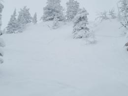
The mountains received another 1-4” of fluffy snow yesterday, with the Bridger Range and mountains around West Yellowstone getting the most. This morning temperatures are in the single digits F with 5-15 mph winds from the south to the west. Today, temperatures will reach the teens to 20s F with 5-15 mph winds from the south to the southwest. A trace of snow is possible.
The allure of fresh snow and a calm day is strong, but do not mess with deep slab instability, and don’t think you can outsmart it. Dangerous avalanche conditions exist, but a skier or rider won’t trigger a slide every time they touch a steep slope. With snowfall tapering off yesterday morning after a lightweight 1-4” fell, slopes will be slightly less sensitive to human triggers today. However, our trust in the snowpack is low after a weekend that included an avalanche resulting in a life-threatening injury just outside the advisory area (details and photos), a close call with a 4-5 foot deep avalanche on Hyalite Peak (details and photos), a 2-3 foot deep snowmobiler-triggered avalanche at Buck Ridge (photo and details) and 4-5 foot deep natural avalanche on Miller Mountain in Cooke City (photos and details). Go back another week on our avalanche incidents page and find four partial burials in the Cooke City area, plus a near miss in Cabin Creek, a natural avalanche in the Taylor Fork (video), a partially buried sled at Daisy Pass (video) and a partially buried rider in the Lionhead area.
We consider many of these slides deep slab avalanches. These are particularly scary because they are large and could easily be unsurvivable, signs of deep instability before an avalanche are limited to non-existent, stability tests aren’t as effective in yielding relevant information and many people may travel across a slope before someone hits the wrong spot, and it releases. In addition, some of these avalanches are failing in terrain just over 30 degrees on a weak layer of feathery surface hoar that survived long after being buried by snow in January.
Mitigate the risk of these large avalanches by making conservative terrain choices. Slopes under 30 degrees are generally safe, and lower-elevation and non-wind-loaded slopes are safer than upper-elevation alpine terrain with hard slabs of wind-drifted snow.
The second concern is avalanches failing within the new and wind-drifted snow. While smaller, these could be large enough to carry, injure or bury a skier or rider, especially where terrain traps are present. Yesterday, skiers north of Bridger Bowl saw several natural and human-triggered avalanches within the recent snow (observation and photos). Sunday, Alex triggered shooting cracks at Buck Ridge (video) and a group intentionally triggered sensitive slabs in the Northern Bridger Range that broke 5-10” deep (details and photos). On Saturday, a skier narrowly avoided a scary ride over cliffs in Hyalite Canyon in a relatively small avalanche (photos and details). Identify and avoid instability related to the new and wind-drifted snow by noticing signs like shooting cracks or recent avalanche activity.
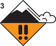
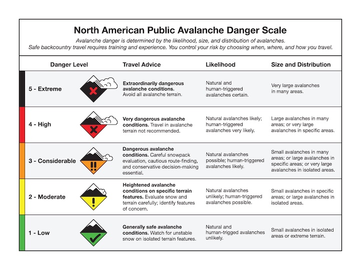
The danger is rated CONSIDERABLE.
Please share avalanche, snowpack or weather observations via our website, email (mtavalanche@gmail.com), phone (406-587-6984), or Instagram (#gnfacobs).

Near-constant snowfall for two weeks has created dangerous avalanche conditions (recent observation). Avalanches breaking deep within the snowpack are possible. Mitigate the risk of these large avalanches by making conservative terrain choices. Slopes under 30 degrees are generally safe, and lower-elevation and non-wind-loaded slopes are safer than upper-elevation alpine terrain with hard slabs of wind-drifted snow. Smaller avalanches within the new and wind-drifted snow are likely. Identify and avoid these instabilities by noticing signs like shooting cracks or recent avalanche activity.
Upcoming Avalanche Education and Events
Our education calendar is full of awareness lectures and field courses. Check it out: Events and Education Calendar.
March 9, 6 p.m.-7 p.m., 1-Hour Awareness - Spring conditions. FREE at REI Bozeman.
March 10 & 11, SheJumps - Women’s Companion Rescue Clinic. Online classroom session Friday evening followed by a field session from 10 a.m.-2 p.m. Saturday. More information and registration HERE.
Every Saturday, 10 a.m. - 2:00 p.m. Avalanche Rescue Training, drop in for any amount of time. Round Lake Warming Hut, Cooke City. Free.
Loss in the Outdoors is a support group for those affected by grief and loss related to outdoor pursuits. Check out the link for more information.
A list of all avalanche activity from our forecast area can be viewed HERE.