Advisory Archive
Mountain temperatures are in the high single digits and winds are averaging 30-40 mph out of the west to southwest with gusts ripping to 70 mph. Cooke City has seven inches of new snow with Taylor Fork and West Yellowstone showing two inches. Today, winds will decrease, but still blow strong with temperatures rising into the teens. Snowfall will pick up later today and by tomorrow morning I expect 2-4 inches in the northern mountains and 6-8 inches in the southern zones. Tomorrow looks to be snowy too.


Mountain temperatures are six below zero this morning with ridgetop winds blowing 20-30 mph out of the west to southwest. Chilly. Early yesterday morning another inch fell near Cooke City and last night scattered showers dusted parts of the Madison Range. Winter has finally turned a corner and is poised to barrel down on us. Scattered showers today and tonight will become more sustained Wednesday and Thursday. By tomorrow morning I expect 1-2 inches in the north and 3-4 inches in the southern mountains. Today, winds will steadily increase out of the west to 40 mph as mountain temperatures warm to near 10F. Snow, wind and cold temperatures; what a concept!


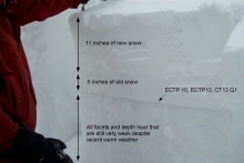
Over the past 24 hours a cold winter storm has delivered nine inches of low density snow to the Bridger Range, 3-4 inches to the mountains around West Yellowstone and Cooke City and 2-3 inches in the northern Madison and Gallatin Ranges.
Falling temperatures have arrived with the falling snow. Currently mountain temperatures are ranging from the single digits above or below zero and winds are blowing 5-20 mph out of the WNW with the exception of the Bridger Range where they are blowing 5-15 mph out of the east. Today, light snow will continue to fall in the northern mountains with an additional 1-2 inches possible. Temperatures will remain cold with highs in the teens and lows tonight around zero F. Snow will end by this evening, but winds will increase to 20-30 out of the W.


Warm and windy conditions are currently in place ahead of an approaching cold front. At 4 am this morning winds are blowing steady at 25-35 mph out of the WNW with gusts reaching into the 50s. Mountain temperatures are in the mid to high 20s under mostly clear skies with the exception of Cooke City where a 1-2 inches of snow has fallen overnight. A significant change in weather will take place as the day progresses. A cold front will arrive by early afternoon creating mostly cloudy skies, falling temperatures and an increasing chance of snow showers. By tomorrow morning temperatures will be in the single digits and 2-4 inches will likely accumulate in the mountains.

This morning in the northern areas near Bozeman and Big Sky, mountain temperatures were in the low 20s F and winds were blowing 20-40 mph from the W. Further south near West Yellowstone and Cooke City, temperatures were in the low teens F and winds were blowing 10-20 mph from the SW. Today will warm into the high 20s F and winds will increase ahead of an approaching cold front. Next week may get snow every day. While no snow will fall by tomorrow morning, we will see Tom Brady and the Patriots crush the Broncos this evening.

This morning mountain temperatures were in the mid teens F except near West Yellowstone and Cooke City where temperatures were in the single digits F. Ridgetop winds were blowing 5-15 mph mostly from the W with gusts of 25-35 mph. Over the Bridger Range and Hyalite winds were blowing stronger at 25-40 mph. Today will be similar to yesterday. Under mostly sunny skies temperatures will warm into the mid 20s F. Winds shouldn’t change much and remain westerly blowing 10-15 mph with gusts of 20-30 mph. Weather models continue to show the current ridge of high pressure flattening on Sunday followed by a trough of low pressure approaching SW Montana. This trough will bring cold temperatures and some precipitation.
This morning mountain temperatures were in the low teens F except near West Yellowstone and Cooke City where temperatures were near 0 degrees F. Ridgetop winds were averaging 15-25 mph mostly from the NW. A ridge of high pressure off the west coast is affecting our weather by blocking moisture and creating a NW flow over Montana, a common pattern this winter. This ridge will hopefully flatten late this weekend allowing a chance of precipitation. Today will be mostly sunny with some clouds, temperatures will rise into the low 20s in most areas, and ridgetop winds will blow 10-25 mph from the NW.

Everyone got an equal helping of cold temperatures and wind, but not snow. The Bridger Range along with West Yellowstone got skunked and only picked up an inch. The northern Gallatin Range and mountains around Cooke City got 6-8 inches while the Big Sky area and southern Madison Range got 3-5 inches. Mountain temperatures this morning are zero to -10F with 5-10 mph winds out of the northwest, but 20 mph out of the east in Cooke City. As the snow fell yesterday, west to northwest winds blew strong and averaged 20-30 mph with gusts over 40 mph. Today will be sunny, temperatures will rise into the teens and winds will remain calm. The next snowfall is predicted to be…Sunday night.

Under sunny skies temperatures reached the mid 30’s yesterday with westerly winds averaging 10-20 mph. Today will be different. A dynamic and moist cold front will roll through this afternoon bringing snowfall through tonight. West winds have already increased to 20-30 mph and will notch higher while temperatures fall to the single digits this evening. The mountains should get 3-6 inches by tomorrow morning; however, it’s a strong northwest flow and dare I suggest the Bridgers may get a wee bit extra?

Over the past 24 hours a cold northwest flow dropped a trace to one inch of snow in the northern Gallatin and Madison Ranges. This weak system has been pushed to the east by a building ridge of high pressure, which is producing clear skies and relatively calm conditions.
Currently, mountain temperatures are ranging from the high teens to mid twenties and winds are blowing out of the WNW at 5-15 mph, with the exception of the Bridger Range where ridgetop winds are blowing 25-35 mph. Today, skies will remain clear and temperatures will climb into the low 30s F. Winds will gradually increase through the day, blowing 20-30 mph out of W. Skies will become partly to mostly cloudy by this evening as the next weather system approaches from the west.