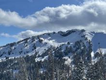
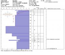
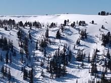
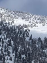
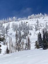
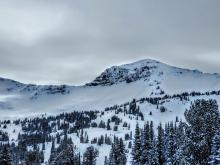
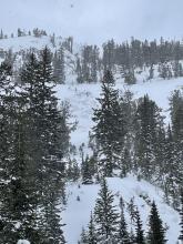
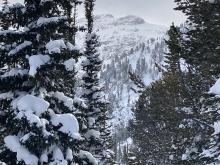
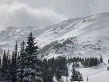
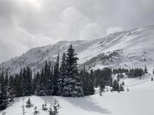
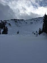
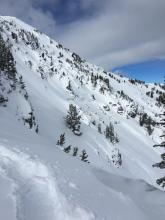
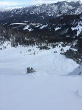
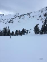
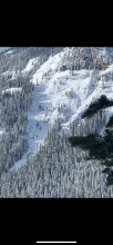
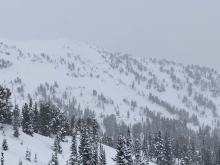
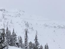
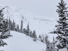
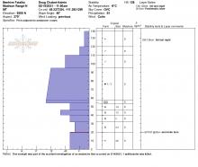
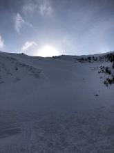
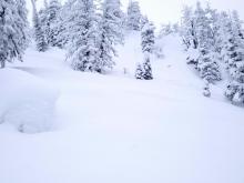
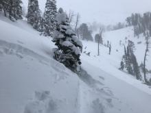
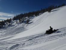
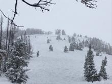
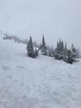
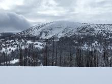
All Avalanche Incidents for Advisory Year 2020-21
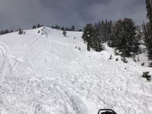
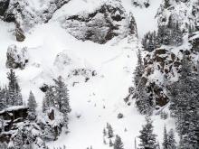
WS-N-R3-D3-O
Elevation: 10,000
Aspect: N
Coordinates: 44.9691, -109.4720
Caught: 0 ; Buried: 0
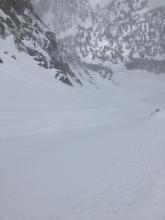
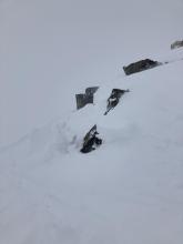
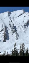
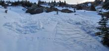
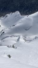
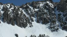
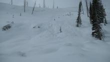
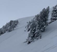
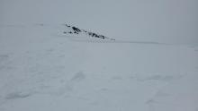
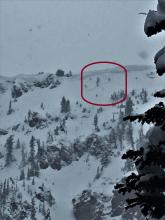
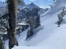
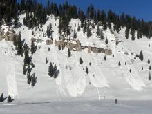
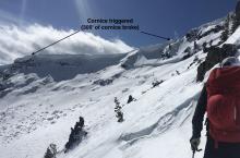
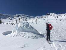
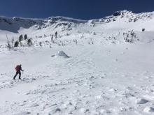
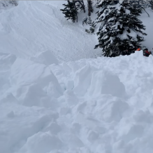
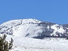
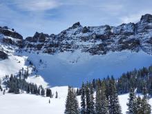
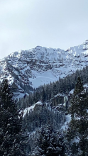
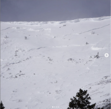
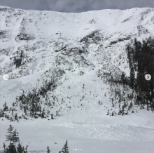
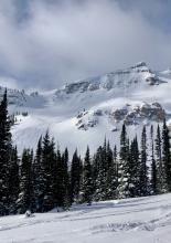
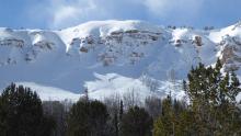
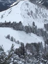
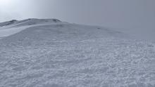
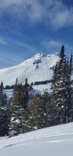
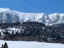
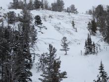
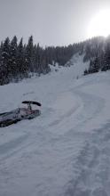
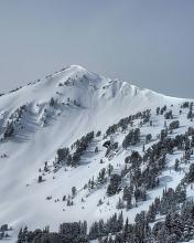
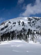
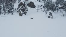
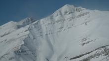
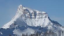
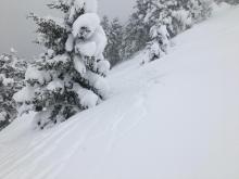
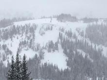
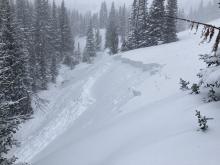
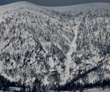
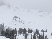
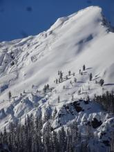
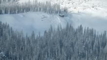
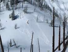
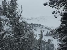
This huge avalanche occurred Friday June 4, 2021 near Beartooth Basin ski area, above Twin Lakes on Beartooth Pass. Multiple days of exceptionally warm temperatures followed by rain caused a large cornice to break and trigger the nearly 10' deep wet slab.
More Avalanche Details
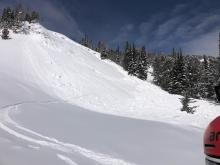
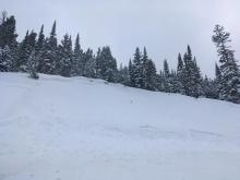
SS-AS-R1-D1.5-I
Elevation: 10,000
Aspect: NE
Coordinates: 45.3407, -111.3910
Caught: 0 ; Buried: 0
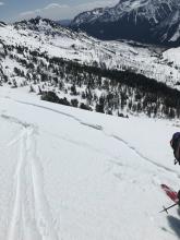
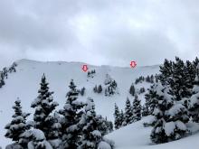
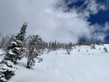
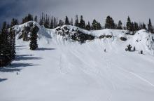
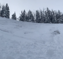
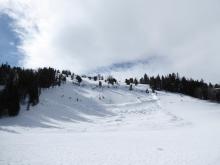
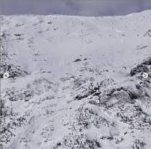
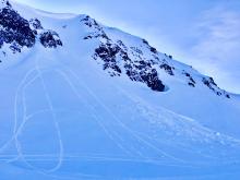
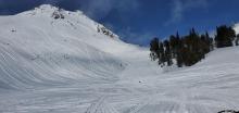
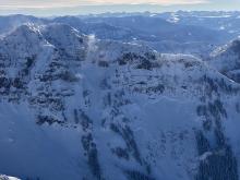
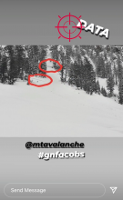
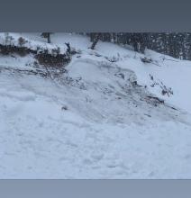
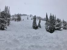
From obs: 5/9/21: "Yesterday we went to check out the new snow in Beehive Basin.... While traversing... along the north ridge of 10602, we triggered a small wind slab that carried down into Peruvian, which then released another small wind slab on a northeast aspect of the face (photo). The crown height of this wind slab was measured at 60cm at it's deepest point, and approximately 30ft wide by 10ft long.
Looking down into the face of Peruvian, we observed a natural dry loose slide that released from the ridge. We observed an increase in wind speed throughout the morning, and a shift in wind direction from west to southwest in the early morning moving to west to north west by the late morning."
More Avalanche Details
WS-N-R2-D2-O
Elevation: 9,500
Aspect: NW
Coordinates: 45.0607, -111.2720
Caught: 0 ; Buried: 0
Multiple wet slides were reported in southern Madison and Tobacco Roots over the week 5/3-5/7.
More Avalanche Details
WL-N
Coordinates: 45.0202, -109.9380
Caught: 0 ; Buried: 0
From email 5/2/21: "Small but plentiful wet snow avalanches in Cooke City today. Didn’t see any that were broke on a deeper scale."
More Avalanche Details
WL-N
Elevation: 9,000
Aspect: NE
Coordinates: 45.0003, -109.9540
Caught: 0 ; Buried: 0
From obs 4/30/21: "Yesterday I witnessed a big wet slide. It started on the exit from The Fin on Old Man Rays. Looks like it started on a rock band. Noon. Since people have been skiing The Fin recently I just happened to be looking up there and saw movement. It quickly quadrupled and then flowed across the ski line and over the cliff band. Spectacular. Flowed like a water fall for about a minute."
More Avalanche Details
WL-N
Coordinates: 45.8512, -110.9480
Caught: 0 ; Buried: 0
From obs: "I traversed the Bridger range yesterday (4/28/21). The alpine start was good and solid but I saw lots of recent avalanches that looked super wet, some that had broken a couple feet deep. Conditions were pretty stable until about 1300 when that most recent snow layer started to really want to slide on the crust. Once I was in the meadows between Baldy and the M, at about 1400, I started hearing/feeling really wet "whumps".
More Avalanche Details
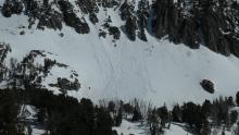
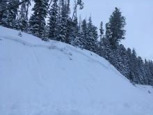
WL-N-R2-D2
Elevation: 9,000
Coordinates: 45.4260, -110.4950
Caught: 0 ; Buried: 0
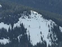
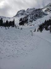
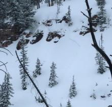
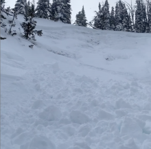
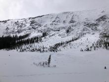
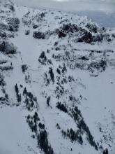
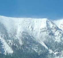
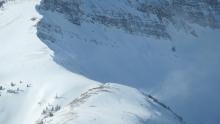
From obs 4/28/21: "Observed numerous natural wet loose slides probably occurring over the past 48 hours on NW-W-S aspects mid-elevation. Point releases from rock bands and couloirs shedding. Photo for example, which shows W facing bowl with slides visible from US-89 in Paradise Valley. These are between 8500’ and 9500’ on an unnamed peak just northeast of Dexter Point."
More Avalanche Details
SS-N-R1-D1.5-I
Elevation: 8,500
Aspect: NE
Coordinates: 45.8156, -110.9230
Caught: 0 ; Buried: 0
More Avalanche Details
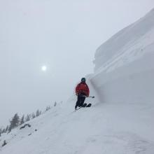
SS-N-R1-D1
Aspect: NE
Coordinates: 45.4959, -110.4490
Caught: 0 ; Buried: 0
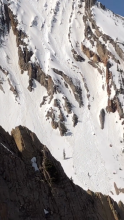
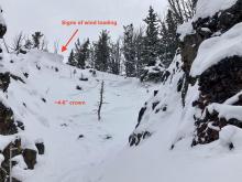
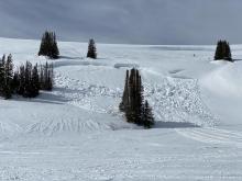
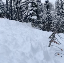
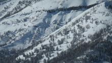
From obs 4/9/21: "we saw widespread natural wind slabs on N-NE eastern slopes in the Northern Absarokas (photo)...."
More Avalanche Details
Elevation: 9,000
Aspect: S
Coordinates: 45.0423, -109.9650
Caught: 0 ; Buried: 0
Skiers had a collapse which made this crack on a south facing slope with a shallower, wet snowpack around 9,000' near Cooke City.
More Avalanche Details
WS-N-R2-D2-O
Elevation: 8,200
Coordinates: 45.6553, -110.5580
Caught: 0 ; Buried: 0
A wet slab was reported on 4/4/21 around 8,200' elevation in the Main Boulder drainage south of Big Timber, outside of our advisory area. It happened that day or very recently during extended above freezing temperatures.
More Avalanche Details
WL-N-R2-D2-S
Elevation: 9,000
Aspect: SE
Coordinates: 45.9233, -110.9800
Caught: 0 ; Buried: 0
Skiers watched a large natural wet loose slide happen on the afternoon of 4/3/21. SSE aspect.
More Avalanche Details
WL-N-R2-D1.5
Coordinates: 45.3407, -111.3910
Caught: 0 ; Buried: 0
Some of the wet loose avalanche activity around Beehive Basin is getting large enough to be dangerous in its own right, other activity is dangerous because it could push us into hazardous terrain.
More Avalanche Details

WL-N-R1-D1.5-S
Elevation: 8,900
Aspect: SE
Coordinates: 45.9043, -110.9580
Caught: 0 ; Buried: 0
We saw wet loose avalanches on 4/3/21, on aspects that receive sun and have steep rocky features, likely ran over previous days.
More Avalanche Details
SS-N-R1-D1
Elevation: 9,400
Aspect: NE
Coordinates: 44.9710, -111.3100
Caught: 0 ; Buried: 0
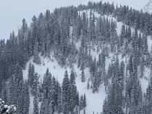
Three natural avalanches in Sage Basin and two natural avalanches in Sunlight Basin failed on 3/28 and/ or 3/29 on heavily wind-loaded slopes. All were relatively small, but a good indicator of the hazard at higher elevations or larger terrain.
More Avalanche Details

SS-N-R1-D1.5
Coordinates: 45.7943, -110.9360
Caught: 0 ; Buried: 0
A natural wind-slab avalanche released below the upper cliffs on Saddle Peak on March 28th.
More Avalanche Details
SS-ARu-R1-D1-S
Coordinates: 45.0202, -109.9380
Caught: 0 ; Buried: 0
From IG: Had 6-inch wind slab break and run in Y couloir on Miller on March 28th.
More Avalanche Details
SS-N-R1-D1
Elevation: 10,000
Coordinates: 45.4164, -110.9700
Caught: 0 ; Buried: 0
More Avalanche Details

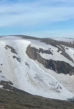
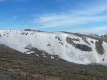
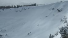
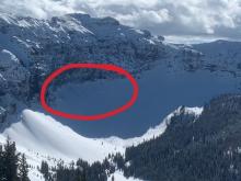
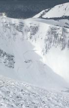
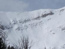
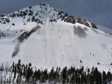
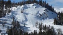
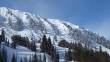
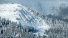
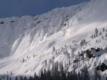
SS-N-R3-D2-S
Elevation: 11,200
Aspect: NE
Coordinates: 45.1350, -109.8880
Caught: 0 ; Buried: 0
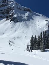
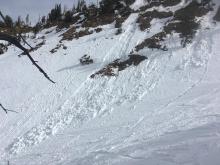
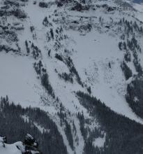
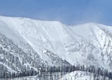
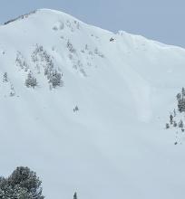
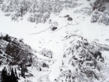
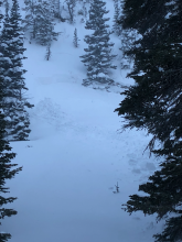
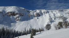
From obs: "... an avalanche we saw out by Goose Lake yesterday (3/27)... we are pretty sure this wasn't there at 8am. On the way back (5pm) we noticed this large avalanche on the NE face of Iceberg Peak at about 11,200. It broke naturally in the new snow which was drifted heavily by SW winds (20-40mph all day). It appears to be 3-4' deep at the deepest spots, 600' wide, and ran 750'. There is a small area below the upper crown that stepped down, but tough to tell if that was just snow from the start of this storm. We did not notice any other activity in the area..."
More Avalanche Details
AMu-R2-D2-O
Elevation: 9,200
Aspect: N
Coordinates: 45.1723, -111.4430
Caught: 0 ; Buried: 0
From obs: "Saw this slope which frequently slides had been triggered on our way out last night. Slid to the ground but I expect it was mostly new snow was there is a larger old crown visible further uphill.... I did see two other small pocket slides yesterday also in new snow on bed surfaces of older slides.... General snowpack is getting very deep now but a thick junk layer remains at the ground everywhere I dug sleds out."
More Avalanche Details
SS-ASc-R2-D1.5-S
Elevation: 9,600
Coordinates: 45.4050, -110.9420
Caught: 0 ; Buried: 0
From obs: "...We continued up and decided to stick to a ridgeline with trees in order to avoid the surrounding gullies which we believed may be cross-loaded. Near the top of the ridge (Around 9800') our options narrowed to either committing to climbing a gully or turning around, and after a couple hand shears we noticed the new snow was becoming stiffer and sliding easily on the crust so we ripped skins and turned around.
Our route had one area of concern on the way down, which was a small gully between a cliff band. I made a ski cut towards the top since the terrain had (relatively) lower consequence and was able to release a wind slab roughly 4-6" deep. The deeper area to the right was the descent track from group members 2 and 3 after the wind slab had released."
More Avalanche Details
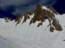
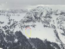
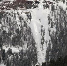
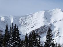
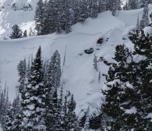
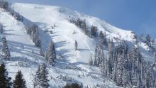
HS-ASr-R2-D2-O
Elevation: 9,500
Aspect: NE
Coordinates: 45.4407, -110.9990
Caught: 0 ; Buried: 0
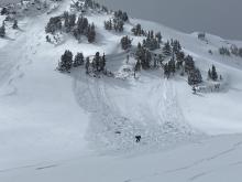
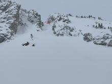
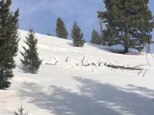
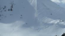
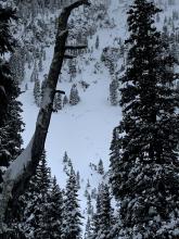
From obs: "Skied Mount Blackmore today. around 1 pm a skier remote triggered a deep slab from ~50 feet away (around the corner lookers right in the attached picture). Broke at the ground, 10-15feet deep, and took out a small tree."
From obs: "My partner and I observed a deep slab avalanche in Blackmore Basin that appeared to break on the depth hoar near the bottom of the snowpack. It was on a wind loaded NE facing slope at approx. 9,500 and looked to break on a slope in the 35-40 degree range. The crown was about 8'-10' deep and 200' wide. It broke to the ground and ripped out several small trees. As soon as we saw it, we came over a small ridge to see another skier near the debris. According to him it was triggered remotely by one of the two skiers on the coming down on the lookers right of the slide... We confirmed that a beacon search was done to make sure no one was buried."
More Avalanche Details
SS-AS-R1-D1
Elevation: 9,500
Aspect: E
Coordinates: 45.4425, -111.0010
Caught: 0 ; Buried: 0
From obs: "Observed a small skier triggered slide on the middle ridge of MT Blackmore today, skier was cutting across when it released."
From obs: "Skied Mount Blackmore today. There was a lot more new snow than expected (6-8") and ridgetop winds were strong and gusty. Snow along the ridgelines and on E-facing slopes was touchy. Lots of cracking and collapsing. Saw 4 skier triggered slides on the E face between the Blackmore and Alex Lowe Basins. Most appeared to be wind slabs,..."
More Avalanche Details
HS-N-R2-D2
Elevation: 9,500
Aspect: N
Coordinates: 45.4402, -110.9310
Caught: 0 ; Buried: 0
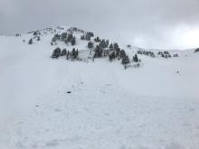
From obs: "Skied Mount Blackmore today. Saw a natural avalanche on Alex Lowe peak just south of the Hellmouth,..."
Other group's obs: "I and one friend observed the remains of a natural avalanche below the north facing headwall up Flanders creek. It looked as if it happened within the past few days. I didn’t get close enough to really gauge the size in width but it propagated at the ground. The crown looked to be 3’-4’ deep..."
More Avalanche Details
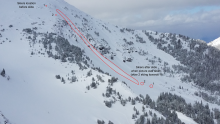
SS-AS-R2-D2-S
Elevation: 10,000
Aspect: E
Coordinates: 44.9786, -111.4150
Caught: 0 ; Buried: 0
From obs: "We were skinning up Pyramid Point from the East. as we approached 10,000 ft, we encountered a wind slab on an East Facing slope. it was about 1-2 inches where we encountered it but it quickly propogated. the crown was 18-20 inches at its highest and about 150 feet wide. the debris ran for about 200 feet."
More Avalanche Details
SS-ASu-R1-D1
Elevation: 8,000
Aspect: E
Coordinates: 45.0080, -110.8370
Caught: 0 ; Buried: 0
Small slab avalanche on Electric Peak in the southern Gallatin Range.
From obs: "...I did get one small slab to pull on the crust layer on an E aspect at 8000’, so the snow has proven to not be uniformly well-bonded..."
More Avalanche Details

SS-ASu-R1-D1
Coordinates: 45.3426, -111.3840
Caught: 0 ; Buried: 0
From obs: "On Friday, my partner and I went into Middle Basin with the objective of skiing Middle Peak, and possibly the short couloir that splits the face. That morning we dug a pit on the east facing aspect of the beehive/middle basin ridge (ECTx). Encouraged by our results, we continued on to the base of middle peak and dug another pit (ECTp 30) on the south-facing ice crust. We continued on to summit middle peak and ski down the face to the entrance of the couloir, we descended 20ft into the entrance on soft loose snow and dug our third pit (ECTx), we replicated our results and decided the feature would be safe to ski. At ~1pm the first skier descended the slope, and triggered a small windslab (4-8in and 20ft wide) about 100ft down the slope and skied away uncaught. Skier 2, descended a lower angle slope to the east."
More Avalanche Details
Coordinates: 45.8397, -110.9330
Caught: 0 ; Buried: 0
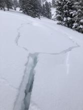
7:30pm - Cracks and whumpfing observed on the south aspect of Texas Meadows, north of Bridger Bowl. There was an obvious wind loading pattern with a 4-5 foot cornice building. Whumpf propagated 20-25 ft across the slope.
More Avalanche Details
SS-AFu-R1-D1-S
Aspect: N
Coordinates: 45.4473, -110.9420
Caught: 0 ; Buried: 0
We left the car with subdued expectations this morning, but were happy to find the new snow bonding well where it hadn’t been slab-ified by the wind. Near the top of Mummy’s North Couloir a shallow (<6”) soft slab broke at my feet as I was wallowing up the boot pack and ran a decent way down the gully- harmless in that spot but with more exposed terrain above we turned tail and enjoyed some excellent skiing.
More Avalanche Details
NC-R1-D1-S
Aspect: E
Coordinates: 45.4599, -110.9980
Caught: 0 ; Buried: 0
On Monday, March 22, skiers toured west of Blackmore Lake and observed a natural slide of the new snow below a cornice.
More Avalanche Details
L-AS-R1-D1-I
Aspect: SW
Coordinates: 45.3407, -111.3910
Caught: 0 ; Buried: 0
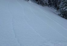
From email: "We both set off some small sluffing on the west side of the ridge between Middle and Beehive on our way out; the snow on that aspect was a lot thinner and more prone to sliding on the older icy crust under the new snow. Photos are from below where we skied out; we dropped onto the west-facing slopes maybe 100' south of the prayer flags."
More Avalanche Details
SS-AS-I
Elevation: 10,000
Aspect: SE
Coordinates: 45.4444, -111.0040
Caught: 0 ; Buried: 0
From email: "On our way out (from Alex Lowe Peak) we watched two skiers climbing to the top of a gully on the SE face of Blackmore... When I looked up again 5 minutes later, the gully had slid. Luckily, based on their tracks it looks like they triggered it from the top without getting caught and then skied it. The first skier was already at the bottom and the second was on his way down."
More Avalanche Details
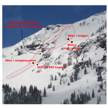
SS-ASc-R2-D1.5-I
Elevation: 9,700
Aspect: E
Coordinates: 45.4272, -111.0140
Caught: 1 ; Buried: 0; Killed: 0
Write up from the party:
"
I am writing to report a slide near Alex Lowe Peak, a little before noon today, Sunday March 21, approximately here: 45°25'34.1"N 111°00'47.0"W, on an east facing slope at around 9,700 ft. The nuts and bolts are: The entire slide path was about 500 vertical feet, perhaps 200 feet wide at its widest. The crown looked to be between 8” and 12” deep. One skier caught, not buried, no injuries. All is good.
Here’s the story to go with it if you care to read. Sorry it’s a long one; I am processing.
We approached from the Blackmore/Elephant saddle and headed towards the bowl just south of Alex Lowe Peak. At around 9,450 ft we stopped to do an ECT and got nothing to move. Still skeptical about how the new snow was bonded to the old snow, we also did a propagation saw test at that interface and got the new snow to budge only after cutting 95% through. The interface felt relatively sticky and the new snow did not slide off the column.
We resumed our ascent, moving south around a rocky outcrop, and then north ‘till we were just about above the outcrop. We had thought about continuing north across the bowl to reach the tree-covered east ridge (it is the way my partner approached it many years ago) but the idea of crossing the bowl above rock outcroppings was not enticing so I instead cut west, directly up the fall line (the bowl is not that steep there). When it got a bit steeper, I starting moving slightly south of west (north would have taken me above the rocks again). My thought was to gain the ridge as soon as possible, and then travel on the relative safety of the ridge. After climbing another 150 feet I felt a startling large whumph. I relaxed for a split second because nothing seemed to be moving but my partner told me “heads up” and when I did look up I realized that the trigger had propagated about 150 feet upslope, to near the ridge. By then, snow was already sliding towards me and I had little time to react. I assessed that the sliding snow was not very deep and not moving very fast and decided to try and dig my edges in. It worked for a second but eventually knocked me off my feet. I glided helplessly past my partner, who had been waiting a 100 feet behind on the skin track. He did not get caught. I slid about 250 vertical feet, to near where had done our ECT. I never picked up too much speed and had plenty of time to think about doing what I could to stay on the surface (kind of star-fished on my back seemed to work). The snow was relatively dense but not cohesive. When the sluff started to slow down to a stop I stood up as tall as I could to hopefully keep my head above snow. Turns out it never got higher than my thighs and I was able to get out with little effort. There is an annotated picture below.
In trying to analyze what we did right and/or wrong I believe that our biggest mistake was to underestimate the effect of wind loading near the ridge, and the fact that the new/old snow interface could be (was) vastly different 250 feet higher in elevation. Ironically, last week after touring in Beehive I personally reported isolated wind slabs, which maybe what got me today. My partner expressed that for him, it was the failure to factor in the “new snow,” having been lulled into a misguided sense that we have now transitioned into spring skiing with a hard settled base. The fact that we do not share the same view may be an indication that we are not communicating as well as we should. Anyhow, what I think we did right was to be continually assessing the “what-ifs” as we were choosing our line of ascent. I think it is what saved us from any serious consequences. I basically slid down the hill on a giant snow couch until I came to a stop. Still, it was an unsettling experience.
Incidentally, on our way out we watched two skiers climbing to the top of a gully on the SE face of Blackmore, which made me nervous. When I looked up again 5 minutes later, the gully had slid. Luckily, based on their tracks it looks like they triggered it from the top without getting caught and then skied it. The first skier was already at the bottom and the second was on his way down. Maybe you will get a report from that in your mailbox too."
More Avalanche Details
SS-ASr-R2-D1.5-I
Elevation: 9,600
Aspect: E
Coordinates: 45.3848, -110.9610
Caught: 0 ; Buried: 0
From obs: "On our way up the summer trail route to Hyalite Peak our party of three remotely triggered a small avalanche from the skin track at around 9,600ft on a east facing aspect. The storm slab went about 4 inches deep and 150-200ft across a small roll over feature. We were about 150ft away when we triggered the slide."
More Avalanche Details
Coordinates: 45.0338, -111.0170
Caught: 0 ; Buried: 0
From obs: "Our group noted a large collapse, including a very loud whoompf and shooting cracks while ascending the SW ridgeline of Meldrum Mountain at roughly 8,000ft. The snow here was between 40cm - 70cm and still had quite a weak, faceted layer underneath..."
More Avalanche Details
C-N-R2-D2
Elevation: 9,500
Aspect: N
Coordinates: 44.9756, -110.0310
Caught: 0 ; Buried: 0
From email: "My partners and I were booting up a couloir near abiathar and a large cornice fell and landed shortly below us in our bootpack. Spooked the hell out of us. We acknowledged the danger of those cornices before booting up, decided that it was probably safe due to relatively low winds and cool temps, and decided to go for it. In hindsight, we wonder if it was much warmer on the ridge near the cornice (we were in the shade), maybe we underestimated the ridgetop winds, or maybe we just got unlucky.
The cornice broke up a bit on some rocks before landing in our couloir, but there still vehicle sized chunks raining down. If we had been 5 minutes slower on the ascent we may have been killed."
More Avalanche Details
WL-N-R1-D1
Elevation: 9,000
Aspect: S
Coordinates: 44.9205, -111.2300
Caught: 0 ; Buried: 0
Three small wet slides on a south facing slope low on Skyline Ridge. Observed 3/13/21. Likely broke in the previous couple of days. Slides were 10-20 ft wide and ran less than 50 ft. Rocks and dirt visible on the slopes where they broke.
More Avalanche Details
L-AS-R1-D1.5-I
Elevation: 10,000
Aspect: S
Coordinates: 45.0709, -109.9450
Caught: 0 ; Buried: 0
A skier triggered a loose snow avalanche in the Rasta Chutes on Scotch Bonet north of Cooke City on 3/10/21. No one was caught.
More Avalanche Details
SS-N-R1-D1-I
Elevation: 9,000
Aspect: E
Coordinates: 45.0202, -109.9380
Caught: 0 ; Buried: 0
Skiers in Cooke City noted this natural storm slab that released on an east aspect at 9000' on March 9th. It broke 6" deep and 25' wide. A second slide was triggered by a mountain goat on a southwest-facing slope, about 1' deep and 25' wide.
Another 1' deep slide was reported on the south face of Meridian Peak at 9500'.
More Avalanche Details
SS-AM-R1-D1.5
Coordinates: 45.0202, -109.9380
Caught: 0 ; Buried: 0
A rider cut across the slope a couple of times before triggering a small, but deep wind-slab.
More Avalanche Details
From obs: 3/6/21: "Observed several smallish avalanches in Yellowstone National Park today. The interesting thing about this one is the bison track that goes into the slide. No telling if the avalanche was triggered by the bison, but the shallow snowpack is about 1/2 faceted, so maybe it was remotely triggered. Resulting in a grizzly springtime snack??"
More Avalanche Details
WL-N-R1-D1-I
Elevation: 9,100
Aspect: SW
Coordinates: 45.3407, -111.3910
Caught: 0 ; Buried: 0
More Avalanche Details
WS-AS-R1-D1
Elevation: 7,200
Aspect: E
Coordinates: 45.3145, -111.2950
Caught: 0 ; Buried: 0
From obs: "While touring above the canyon this morning, I noticed a very recent wet slide (would guess this incident occurred yesterday afternoon, March 4th). This was a skier triggered slide on a E aspect at an elevation of 7200. This slide was roughly 50 feet wide and ran about 50 feet, I estimated this crown to be 2-3 feet deep, slid all the way to the ground. This occurred below a steep roller."
More Avalanche Details
SS-N-R2-D2-O
Elevation: 9,300
Aspect: SE
Coordinates: 44.9880, -110.0330
Caught: 0 ; Buried: 0
Avalanche observed just west of Cooke City, outside our advisory area, in Yellowstone National Park on 3/4/2021.
From email: "a fresh, slab avalanche across the valley late this afternoon... I think it is fresh from the last 48 hours if not from today. It was on a SE aspect, around 9300'. By the time I noticed it the light was off the slope, but I could tell that the flank was deep, and that the avalanche probably ran on facets/ depth hoar near the ground. It looked to be a couple hundred feet wide, and at least 3-4' deep."
More Avalanche Details
HS-N-R3-O
Elevation: 10,100
Aspect: SW
Coordinates: 44.9777, -111.4890
Caught: 0 ; Buried: 0
Reported 3/4/21... date of occurrence estimated.
More Avalanche Details
HS-N-R3-D2.5-O
Elevation: 10,000
Aspect: E
Coordinates: 45.4115, -110.9880
Caught: 0 ; Buried: 0
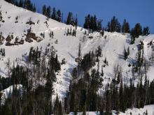
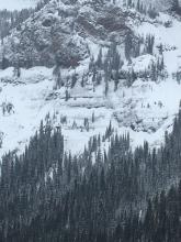
From obs 3/6/21: "Two large natural avalanches in Maid of the Mist Basin. One of them ran on the east face of Arden Peak (Peak 10,201) which propagated across the entire face. Could have been triggered by a cornice fall then stepped down to deeper layers. The second was on the NE face of the peak Fat Maid and Skinny Maid come from. Also propagated across the entire slope. Crown height between 6'-8' in most places." Timing of these slides is unknown. Probably in the last week, but maybe older.
More Avalanche Details

SS-N-R1-D1
Elevation: 7,800
Aspect: SE
Coordinates: 45.0265, -111.0480
Caught: 0 ; Buried: 0
From obs: "Small D1 avalanche on south-eastern aspect around 7800ft."
More Avalanche Details
SS-AMu-R2-D1.5
Elevation: 10,000
Aspect: SW
Coordinates: 45.0497, -109.9640
Caught: 0 ; Buried: 0
From obs: "Here are two photos of what I think is a natural slide from this morning (3/1). Looks like a natural slide across from Crown Butte at the top of Daisy Pass. Crown is at least a few feet."
From another rider: "we spoke with a snowmobiler on the trails on Sunday and he mentioned his group initiated that slide Sunday morning."
Forecaster note: The paths immediately to the left and right of this slope avalanched with a snowmobile trigger on 2/13. Photos and video are here: https://www.mtavalanche.com/node/24256
More Avalanche Details
SS-ASu-R3-D2-O
Aspect: NE
Coordinates: 45.1912, -111.4430
Caught: 0 ; Buried: 0
https://www.instagram.com/p/CL4xIk5n8PZ/
Sled Skiing in Third Yellow mule... after an air onto the slope the impact from landing resulted in a fracture and failure to / near the ground... in addition, a remote trigger occurred on adjacent slope... 200-300 ft to the skiers right. No body was caught in either slide. Skier that initiated failure was moving at high speed and was beyond slide path before majority of snow movement began. 2 pits where dug prior to riding terrain. One on adjacent slope, we went through to ECT 30 and continued to hammer on the column through 40 wacks of double fist, full force before failure occurred 30 cm above ground. Second pit was dug on slope where slide was initiated... same results, very hard to get failure to occur. Snowpack depth varied from 125 - 180 cm in the area... our pits were dug in depths of around 125 cm and 170 cm respectively.
More Avalanche Details

HS-AMu-R4-D2-O
Coordinates: 44.8949, -111.2280
Caught: 0 ; Buried: 0
Riders triggered this slide on 2/28/21 near Red Canyon/Cabin Creek, north of West Yellowstone. Nobody caught or injured, but close call.
More Avalanche Details

U-N-R2-D3
Aspect: NW
Coordinates: 45.0668, -111.0500
Caught: 0 ; Buried: 0
"On the drive back (from Speciman Ck) we saw a large crown on the NW face of Big Horn Peak." It was first noted the afternoon of Sunday, 2/28 and either broke that day or the day before.
More Avalanche Details
SS-NC-R3-D2-O
Elevation: 9,250
Aspect: NE
Coordinates: 45.0607, -111.2720
Caught: 0 ; Buried: 0
This avalanche failed on a heavily wind-loaded slope in Sage Basin along the ridgeline. It may have initiated as a cornice fall or a wind-slab, but it broke down to deeply buried facets. Even though it was a small slope, the slide had enough power to knock down a tree and piled debris deeply at the bottom of the slope.
More Avalanche Details

SS-ACu
Coordinates: 45.8512, -110.9480
Caught: 0 ; Buried: 0
From obs: "Observed a small avalanche while teaching a rec. 1 today for MSU. The light was too flat to see a crown. Based on the light wind, ski patrol obs. and our moving obs., I hypothesize that it was a dry, loose avalanche. L-N-R1-D1.5-I."
Patrol reported: "A midday report from [a skier] that he had released the Duane's Cornice (out of bounds to the north) as he travelled to the ramp had us looking for any tracks below, none were observed. It looked to step down and pull some older layers as it went through the lower pinch."
More Avalanche Details
SS-N-R3-D2
Coordinates: 45.1719, -111.3800
Caught: 0 ; Buried: 0
Natural avalanche on Buck Ridge. Observed 2/26/2021. Looks to have failed recently. Propagated widely.
More Avalanche Details
N-R1-D1.5
Elevation: 9,000
Aspect: S
Coordinates: 44.9282, -110.9140
Caught: 0 ; Buried: 0
From obs (2/28/21): "I’ve attached a photo of a small, D1.5, slide I saw on a thin S facing slope at 9000’. It was definitely more than a few days old.
More Avalanche Details
Coordinates: 45.3899, -110.9770
Caught: 0 ; Buried: 0
These avalanches likely broke around 2/24/21 with other avalanche activity. One was above Hyalite Lake the others were, "Observed two dry-loose slides and one slab avalanche on the NE-facing slope of Peak 10,024 in the Shower Creek basin on Sunday (2/28/21) - all were presumably naturally triggered."
More Avalanche Details
HS-N-R2-D3
Elevation: 10,000
Aspect: E
Coordinates: 45.2268, -111.5120
Caught: 0 ; Buried: 0
These deep slab avalanches on the E face of Cedar Mountain (and lower flank) likely avalanched Feb 23 or 24.
More Avalanche Details
HS-N
Aspect: E
Coordinates: 45.4382, -110.9900
Caught: 0 ; Buried: 0
Ice climbers across Hyalite Canyon near G2 saw a wide and deep crown across the east face of Elephant Mountain.
More Avalanche Details
SS-N-R1-D1.5
Coordinates: 44.8720, -111.3610
Caught: 0 ; Buried: 0
This small natural avalanche broke on a steep, rocky slope in Beaver Creek.
More Avalanche Details
HS-N-R2-D2.5
Elevation: 9,800
Aspect: E
Coordinates: 44.9952, -109.9080
Caught: 0 ; Buried: 0
Skiers saw this slide in Hayden Creek on 2/25/21. It appeared up to 3-6' deep and 200' wide. ENE aspect at 9,800' elev.
More Avalanche Details
HS-NC-R2-D2
Elevation: 10,500
Aspect: E
Coordinates: 45.0530, -110.0100
Caught: 0 ; Buried: 0
More Avalanche Details
SS-N-R2-D2-I
Aspect: NE
Coordinates: 45.0202, -109.9380
Caught: 0 ; Buried: 0
1. A natural wind slab avalanche broke beneath a cornice on Henderson Mountain, near Cooke City. It appears to have broken at the new-old interface, 2-3 ft deep and ~300 ft wide. Likely ran overnight on Monday 2/22/21 or early morning Tuesday 2/23/21.
2. Another smaller wind slab also broke further down the path.
3. A small slide under Sheep Mtn on a E aspect. Size 1, natural. Lots of transport today out north, with dense punchy snow on most aspects. Definitely slabbing up.
4. Photo attached. I saw this SS-N-R1D2 on an E aspect at 9,000’ on the east side of republic mountain into Republic creek. I’m guessing it involved the HN plus some wind loading on old facets on a steep rocky face.
5. Southeast ridge of Mt Abundance broke under the wind-loads. It propagated a few hundred feet.
More Avalanche Details
HS-R2-D2
Elevation: 9,000
Aspect: NE
Coordinates: 45.2771, -111.4640
Caught: 0 ; Buried: 0
The Angry Hairpiece in the Lone Lake Cirque broke as a deep slab sometime in the last 24 hours.
More Avalanche Details
SS-N-R2-D2
Elevation: 9,700
Aspect: W
Coordinates: 45.0202, -109.9380
Caught: 0 ; Buried: 0
From email: "I saw some older slab avalanches on The Thunderer mountain, in northeast YNP (observed today). These avalanches happened on westerly aspects around 9700'. I'd hypothesize that they happened in correlation with the very strong westerly winds that happened around Feb. 21-22."
More Avalanche Details
More Avalanche Details
SS-N-R3-D2.5-O
Elevation: 9,100
Aspect: N
Coordinates: 45.4531, -110.9970
Caught: 0 ; Buried: 0
From Obs: "Driving back from Grotto Falls trailhead, from the east side of the reservoir I could see this slide on the ridge that extends north from Blackmore above Blackmore lake. The slide was on a north-facing slope around 9,100', large enough to see with the naked eye and clear as day with binoculars. The crown looked multiple feet deep and either meandered, partially hidden from view, by another ridge or a substantial second avalanche a hundred feet away."
More Avalanche Details
SS-N-R2-D1-O
Elevation: 8,200
Aspect: SE
Coordinates: 45.0265, -111.0480
Caught: 0 ; Buried: 0
From obs: "Observed 2 natural avalanches, both on the basal persistent layer I would guess. one maybe a week old, partially filled in (SS-N-D1R2-O), and one that ran in the last 24 hrs (SS-N-D1.5R2-O) on a SE aspect, 35 deg at 8200 ft. I thought it was interesting given the lack of new snow and seeming lack of strong winds in this area. 2/5 ECTs had propagation, we had two large collapses."
More Avalanche Details
SS-N-R2-D2-O
Coordinates: 45.2952, -111.4100
Caught: 0 ; Buried: 0
From email: "Observed natural deep slab probably happened overnight with the strong winds... snowpack in the area was about 3-5’ deep mostly 4F with 20+cm of F depth hoar at the bottom... obviously not strong enough to support the windload."
More Avalanche Details
Coordinates: 45.0256, -109.9370
Caught: 0 ; Buried: 0
"...but just as I was about to drop in a huge whumph and collapse occurred all around me so I bailed. Spooky. This spot has a shallow snowpack on what is essentially a shale field."
More Avalanche Details
HS-AMu-R3-D2-O
Elevation: 9,600
Aspect: NE
Coordinates: 45.1769, -111.4520
Caught: 0 ; Buried: 0
From obs: "Triggered a large slide with a snowmobile. Went all the way to the ground. Crown seemed to range anywhere from maybe 3 ft to 10 ft. Large slabs of snow broke free and slid for about 100 yards."
A second sled-triggered slide occurred Saturday (2/20) on the ESE facing slope at the entrance to McAtee Basin. SS-AMu-R3-D2-O
More Avalanche Details

HS-N-R3-D2.5-O
Elevation: 9,500
Aspect: N
Coordinates: 45.4272, -111.0140
Caught: 0 ; Buried: 0
We saw this crown on 2/20/21. It likely broke 2/19 or 2/18.
More Avalanche Details
Coordinates: 45.5777, -110.9550
Caught: 0 ; Buried: 0
From email:"At 6450 feet on a north facing aspect on Little Mt. Ellis I found a snow depth of 75 cm. I dug a pit and got a Ct -7. Ect - 18, both failing on ground facets at 15-20 cm depth. I didn’t see any slides, but I did feel and hear one whumpf on the way up."
More Avalanche Details
Elevation: 7,500
Aspect: NE
Coordinates: 45.3186, -111.2560
Caught: 0 ; Buried: 0
"While on tour today above the canyon, we observed various snow surfaces. We found heavily windloaded slopes on E/NE aspects. Solar aspects began to develop rollers as rocks began to heat up around noon. We observed a small avalanche on E slope a drainage away, roughly 20 feet wide. While ascending a ridgeline at 7500 elevation, we had a massive woomph and crack that spread 100 feet from the ridge to a roller in the fall line."
More Avalanche Details
HS-N-R4-D3-O
Elevation: 9,600
Aspect: NE
Coordinates: 45.4330, -110.9430
Caught: 0 ; Buried: 0
From obs [2/20/21]: "We observed a large natural slide on Flanders Mountain that likely occurred on Thursday (2/18/21). The crown ranged from 2-5’, but it’s hard to gauge how wide it was, because it covered a lot of elevations. I think there is considerable overlap with the large slide that ran there earlier this season. We did not observe any other slides, collapsing, or cracking, but the wind did pick up in the early afternoon."
More Avalanche Details
HS-N-R4-D3-O
Elevation: 9,600
Aspect: NE
Coordinates: 45.4431, -110.9990
Caught: 0 ; Buried: 0
From email: "I toured into Blackmore [2/19/21] and observed an old snow avalanche at 9600' on the east face of Mt Blackmore. I was there the day before and didn't see any evidence of avalanche activity; strong overnight winds with ample snow available for transport appeared to be enough to tip the scales."
More Avalanche Details

SS-N-R4-D2
Elevation: 8,400
Aspect: E
Coordinates: 45.4164, -110.9700
Caught: 0 ; Buried: 0
An ice climber in Hyalite reported a natural D2 underneath the Maid today. Looked like it ran yesterday (2/18/21).
More Avalanche Details
SS-AMu-R2-D2
Coordinates: 45.0525, -109.9620
Caught: 0 ; Buried: 0
Snowmobile triggered slide on Crown Butte, 2/18/2021.
More Avalanche Details
HS-NC-R3-D2.5-O
Elevation: 8,500
Aspect: SE
Coordinates: 45.7701, -110.9400
Caught: 0 ; Buried: 0
From email: "I just watched this slide from my house on Jackson Creek. It’s south of Saddle Peak."
More Avalanche Details
SS-N-R1-D2-S
Elevation: 8,800
Aspect: E
Coordinates: 45.7943, -110.9360
Caught: 0 ; Buried: 0
2/18/21 at 11:45 GNFAC forecaster observed with binoculars natural avalanche activity within new snow along ridgeline south of Bridger ski area to Bridger peak. There were two 50-100 foot wide slabs that broke in the recent storm snow, in the Pinnacles and on Bridger Peak. Wind was blowing strong from the west and there was a lot of snow transport. Cornices were very large and some had broke and gouged through the recent new snow and ran long distances a few triggered broader loose snow avalanches.
More Avalanche Details
SS-N-R1-D1-S
Elevation: 10,000
Aspect: E
Coordinates: 45.0661, -109.9590
Caught: 0 ; Buried: 0
Small wind-slab avalanche on the shoulder of Fisher Mountain.
More Avalanche Details

SS-AMr-R0-D1
Coordinates: 45.8029, -110.8430
Caught: 0 ; Buried: 0
I triggered a small avalanche along the trail up Olson Creek in the Bangtails. It cracked about 75 feet wide, but only a small amount actually slid.
More Avalanche Details
Coordinates: 44.8381, -111.3430
Caught: 0 ; Buried: 0
From Obs: "Observed a dozen or more collapses while skinning up south-facing aspect between 7500 and 8300ft. Noted shallow snow depth of 2-3ft where collapses were occurring."
More Avalanche Details
HS-R4-D3
Elevation: 9,800
Coordinates: 45.3925, -110.9760
Caught: 0 ; Buried: 0
From Obs: "I skied around the little hills in the basin south of Divide Peak today, and saw quite a bit of recent activity. The southwest corner of Divide Cirque slid on the storm slab and broke 1200-1500’ wide, an east aspect had a crown that exceeded 6’ in places, and the south side of Divide broke 2-6’ deep and ran full track. Things up high are active. I observed no collapsing or cracking, but the signs of instability were still pretty clear"
More Avalanche Details
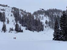
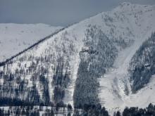
HS-ARu-R4-D2.5-O
Elevation: 9,100
Aspect: SW
Coordinates: 45.3269, -111.3840
Caught: 2 ; Buried: 1; Killed: 1
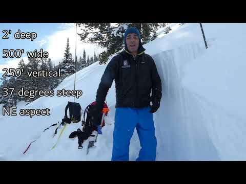
On February 14, 2021, two splitboarders triggered an avalanche in Beehive Basin north of Big Sky. They were skinning up the slope when they triggered the avalanche. Both members of the party were caught, but Boarder 1 was able to grab trees and not be buried. Boarder 2 was carried approximately 300 feet downslope where he hit a tree and was critically injured. He was partially buried, entangled around a tree with his head downhill. Boarder 1 heard his partner’s screams, called 911 and went to his aid. He administered first aid and worked to keep him warm and calm. Gallatin County Sheriff Search and Rescue in Big Sky (GCSAR) left the trailhead within 45 minutes of the 911 call, skied to the scene and began providing care. A GCSAR helicopter arrived soon afterward and the injured boarder was short hauled to Big Sky Fire Department and medical care. Boarder 2 died from his injuries that night. The avalanche was 300 feet wide, 500 feet vertical and averaged 2 feet deep. It broke on a layer of facets and near the ground. Read the full accident report here: https://www.mtavalanche.com/accident/21/02/16
More Avalanche Details

SS-N-R2-D2
Elevation: 10,000
Aspect: W
Coordinates: 44.9739, -109.9240
Caught: 0 ; Buried: 0
From FB: "Winds moderate out of the west. Saw a recent wind slab natural on NW facing starting zone of tube south of Titanic. Ran into titanic approximately 500' vertical where tubes join. D2 in size."
More Avalanche Details
SS-AMu-R1-D1.5
Elevation: 9,950
Aspect: SE
Coordinates: 45.0497, -109.9640
Caught: 0 ; Buried: 0
Saw 2 recent HS-AM-R1-D1 Henderson Ridge, close to Daisy, SE, >35* 9950’ 45.0536, 109.9524
More Avalanche Details

SS-AMu-R3-D2-O
Coordinates: 44.8949, -111.2280
Caught: 0 ; Buried: 0
On 2/13/21 riders reported they triggered this avalanche, and remotely triggered two other slides. Nobody was injured. One partially buried.
More Avalanche Details
SS-R2-D2
Elevation: 8,200
Aspect: E
Coordinates: 45.8301, -110.9340
Caught: 0 ; Buried: 0
On 2/13/21 skiers in the backcountry north of Bridger saw this avalanche occur in wind loaded terrain. They reported a ski track in terrain above, but not sure if it was there already.
More Avalanche Details
N-R2-D2
Elevation: 10,000
Aspect: NE
Coordinates: 44.9952, -109.9080
Caught: 0 ; Buried: 0
From obs: "Natural slab on Climax. Crown was right below the ridgeline and ran almost to valley floor. R2 D2. Not enough vis for a pic... Point releases in steep terrain on Climax."
More Avalanche Details
SS-N-R1-D1.5-I
Elevation: 10,200
Aspect: NE
Coordinates: 45.0566, -109.9510
Caught: 0 ; Buried: 0
Riders observed a small, natural avalanche on the northeast face of Scotch Bonnet on Saturday. The slide likely occurred on Feb 11 or 12.
More Avalanche Details
SS-N-R2-D2
Aspect: E
Coordinates: 44.9560, -111.1320
Caught: 0 ; Buried: 0
Skiers at Bacon Rind saw some fresh looking avalanche activity on northern portion of Ernie Miller Ridge on Feb 14. They suspect it was from the last couple of days.
More Avalanche Details
SS-AMu-R3-D2-O
Elevation: 9,500
Aspect: NE
Coordinates: 44.7145, -111.3180
Caught: 0 ; Buried: 0
Snowmobile triggered slide on Lionhead Ridge in Upper Watkins drainage on 2/11/2021. Appears to have broken on weak snow near the ground.
More Avalanche Details
SS-AMr-R2-D2-O
Coordinates: 45.2890, -111.1410
Caught: 0 ; Buried: 0
On Thursday, Feb 11, snowmobilers remotely triggered two large avalanche in the Portal Creek area.
From obs: "Broke on lookers right crown first then triggered second slide to lookers left (rocks everywhere). Broke on depth hoar on both slides north facing aspects. Nobody was caught."
More Avalanche Details
SS-N-R2-D2
Coordinates: 44.9739, -109.9240
Caught: 0 ; Buried: 0
From email on 2/11: "interesting Av. activity in a Central Park - mid-lower Woody. This is an area that cross-loads like crazy, so it's not surprising to see slides, but the extent was impressive; essentially, slides propagated across the entire zone. These are all mid-slope ~9,000-9,200'"
Likely broke following the wind event on 2/9/2021.
More Avalanche Details
N-R2-D2
Aspect: NE
Coordinates: 45.0558, -109.9470
Caught: 0 ; Buried: 0
This natural avalanche occurred on a wind loaded, NE aspect above Henderson Bench outside Cooke City. Wind-loading has been the main avalanche concern.
More Avalanche Details
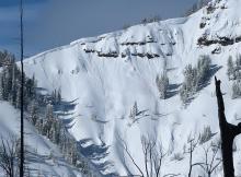
HS-N-R4-D3
Elevation: 10,000
Aspect: SE
Coordinates: 45.0687, -110.0160
Caught: 0 ; Buried: 0
This large avalanche on the SE face of Mt Abundance, north of Cooke City, released naturally in the last 48 hours. In the photo you can see the fingers of windblown snow from strong westerly wind.
More Avalanche Details
SS-N-R2-D2
Elevation: 8,400
Aspect: SE
Coordinates: 45.0256, -109.9370
Caught: 0 ; Buried: 0
The main gully on Town Hill went naturally last night (2/9) with a 3-4' crown.
More Avalanche Details
SS-N-R2-D2-I
Elevation: 9,500
Coordinates: 45.3374, -111.3810
Caught: 0 ; Buried: 0
From email: "Went out in Middle Basin north of Big Sky today and saw 5 separate slides, the largest about 500ft across and approximately 2ft deep. All of them were northeast to southeast aspects from about 9200 to 9800ft. The included photos aren't the best but give an idea of the slides, most are from that largest slide." Photo: B. Richards
More Avalanche Details
HS-N-R3-D2.5-O
Aspect: N
Coordinates: 45.4272, -111.0140
Caught: 0 ; Buried: 0
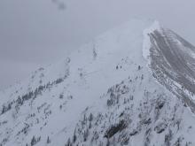
From Obs: "One large avalanche observed, on the path adjacent to the N Couloir on Alex Lowe. More or less went full path, I would estimate 2m max crown depth. HS-N-R4/D2.5-O. A large cornice fell on the NF of Blackmore with no slab results. Observed several size 1 slabs that failed within new snow during the day on N aspects."
More Avalanche Details
SS-N-R2-D3-O
Elevation: 9,600
Coordinates: 45.2268, -111.5120
Caught: 0 ; Buried: 0
I observed 4 avalanches that broke at a variety of aspects and elevations on Cedar Mountain during the tail end of the storm, likely Feb. 5-8, 2021
More Avalanche Details
SS-N-R2-D2
Elevation: 8,400
Coordinates: 45.1719, -111.3800
Caught: 0 ; Buried: 0
I counted 11 natural avalanches in Muddy Creek that failed during the tail end of the storm. They mostly appear to be storm slab avalanches, but some may have broken deeper.
More Avalanche Details
SS-N
Coordinates: 45.1719, -111.3800
Caught: 0 ; Buried: 0
We (GNFAC) observed many (6+) natural avalanches while riding on Buck Ridge. Many looked to be breaking under the storm snow (3+feet; 2.7" SWE), but some looked deeper. We deduced that these ran on Monday, 8 February, because there was only a few inches of snow covering the debris.
More Avalanche Details


SS-R1-D1.5
Coordinates: 45.0202, -109.9380
Caught: 0 ; Buried: 0
From IG Stories: Two avalanches east of Cooke City above Hwy 212. Just west of the state line.
More Avalanche Details
SS-N-R1-D1
Elevation: 8,350
Aspect: NE
Coordinates: 45.8288, -110.9310
Caught: 0 ; Buried: 0
From email: "Skied the ramp outside of Bridger Bowl today, saw these small NE facing crowns at 8350'. We also experienced localized cracking while skinning at the density change interface of the new and "old" snow (8-12" at this elevation by 4pm). No other observed avalanches, no other cracking and no collapsing."
More Avalanche Details
SS-ASu-I
Elevation: 9,100
Aspect: E
Coordinates: 45.0396, -109.9750
Caught: 0 ; Buried: 0
From Obs: "Skiers traveling on South facing slope at 9,100ft elevation ascending Miller Trees remote triggered from skin track (second lap) a wind slab slide on a steeper East facing slope that slid to gully floor and out to Sheep Creek. Westerly wind was blowing with gusts carrying snow to load the east-facing side of the gully. Crown was approximately 4ft at the crest of the gully’s slope. Cracking visible in the photo from skin track traveled up to crown 50yrds away. Pit dug at similar elevation on South facing slope yielded slight cracking within the storm slab but no propagation (ECT16N)."
More Avalanche Details
ASu-R3-D2-O
Elevation: 8,000
Aspect: NE
Coordinates: 45.2311, -111.4410
Caught: 0 ; Buried: 0
This avalanche was triggered from across the boundary line of the YC.
More Avalanche Details
SS-N-R2-D2
Coordinates: 45.3407, -111.3910
Caught: 0 ; Buried: 0
Natural avalanche on an east aspect in Beehive Basin. Likely broke during the avalanche warning on 2/7/2021. Appears to have broken ~4ft deep on weak snow near the ground.
More Avalanche Details
SS-N-R3-D2
Coordinates: 44.7536, -111.3300
Caught: 0 ; Buried: 0
Natural avalanche on Lionhead Ridge in upper Watkins Creek. Likely broke on Sunday 2/7. Appears to have failed on weak snow near the ground.
More Avalanche Details
SS-N-R2-D2.5
Coordinates: 44.9205, -111.2300
Caught: 0 ; Buried: 0
Multiple large natural avalanches ran on Skyline Ridge, on the side facing Cabin Creek and the side facing Teepee/Bacon Rind Creeks. They likely broke during the avalanche warning on Sunday, Feb 7th. One slide on the Cabin Creek side of the ridge ran within 300 ft of the Big Sky Trail. Many of the slides appear to have broken on weak layers near the ground.
More Avalanche Details
SS-N-R2-D2
Coordinates: 45.2995, -111.3200
Caught: 0 ; Buried: 0
A Big Sky resident spotted 5 natural avalanches on Yellow Mountain that failed during the tail end of the storm.
More Avalanche Details
Coordinates: 45.5777, -110.9550
Caught: 0 ; Buried: 0
We saw widespread cracking on several steep slopes on Mount Ellis. 20"+ of new snow loaded a weak snowpack.
More Avalanche Details
SS-N-R2-D2-O
Elevation: 8,500
Aspect: N
Coordinates: 45.3145, -111.2950
Caught: 0 ; Buried: 0
Skiers in Dudley Creek saw recent avalanche in the north facing glades
More Avalanche Details
SS-N-R2-D2
Elevation: 8,500
Coordinates: 45.6553, -110.5580
Caught: 0 ; Buried: 0
These slides were observed in Yellowstone National Park on 2/7/21.
More Avalanche Details
HS-AEc-R5-D3-O
Coordinates: 45.2311, -111.4410
Caught: 0 ; Buried: 0
From YCSP: "We’ve had more snow and SWE in the past 5 days than we had in all of January. Avalanche mitigation today produced avalanches running full path at the new snow/old snow interface for most of our paths.... Some of our lower ridge avalanche terrain climaxed for the 2nd time this season. Our first round of mitigation got a few paths to climax, but the teams didn’t feel confident with the initial results.... They went back out with more explosives and were able to produce an avalanche that ran 400’ wide, with a 6-10’ crown, running close to the ground. This is wind loaded terrain. It’s also perhaps the largest crown I’ve seen on these paths and one of the few times I’ve seen it climax more than once.
I took a drive at the end of the day and captured a few photos of road cuts at the YC that slid today."
More Avalanche Details
U-N-R2-D2-U
Aspect: E
Coordinates: 45.2268, -111.5120
Caught: 0 ; Buried: 0
A patroller a the YC saw a slide on some of Cedar Mountain’s lower east facing terrain on 2/7/21.
More Avalanche Details
HS-N-R2-D2-O
Elevation: 8,700
Aspect: NW
Coordinates: 45.7976, -110.9380
Caught: 0 ; Buried: 0
Ski patrol had brief visibility on 2/7/21 to see a large natural avalanche, believed to have ran 2/7/21, on the northwest slopes of Saddle Peak on the West Side of the Bridger Range.
More Avalanche Details
N-R4-D2
Elevation: 8,500
Aspect: SW
Coordinates: 45.0265, -111.0480
Caught: 0 ; Buried: 0
From obs: "GNFAC, You’re never going to believe this, but there was tons of whumphing up in Specimen Creek today! There were a few avalanche classes there digging snow pits and getting unstable test results by the sounds of it. We saw a good sized natural on a steep SW facing meadow around 8500’, probably would call it R4D2 but it was hard to get a good look through the storm."
More Avalanche Details
SS-ASc-R4-D2-O
Elevation: 8,000
Aspect: W
Coordinates: 45.3407, -111.3910
Caught: 0 ; Buried: 0
On 2/7/21 skiers in Beehive reported: "Numerous large collapses, ECTP in several pits on mid-pack facets, and triggered a test slope remotely from flat terrain. It broke in the old snow, but towards to top, maybe 10cm below the interface with the last week’s snow. Propagated over 50m, crown depth 60-100 cm. Would be solid size 2 if the slope wasn’t 20m tall."
More Avalanche Details
SS-N
Coordinates: 45.0202, -109.9380
Caught: 0 ; Buried: 0
Skiers observed several natural avalanches west of Cooke City. All were on wind-loaded slopes. Varying size and destructive potential.
More Avalanche Details
HS-N-R3-D2.5-O
Elevation: 8,600
Aspect: NE
Coordinates: 45.7701, -110.9400
Caught: 0 ; Buried: 0
Seen on 2/9/21: Many natural avalanche crowns along the Bridger Ridge that ran during the storm from 2/4-2/8, likely between 2/5-2/7. Across all of Bridger Peak, some on Baldy Peak, Many through The Pinnacles, Argentina Bowl and Saddle.
More Avalanche Details
SS-ASr-R3-D1.5-G
Coordinates: 45.8512, -110.9480
Caught: 0 ; Buried: 0
Skiers sent an IG post saying they remote triggered this slide from the adjacent road on 2/6/21.
More Avalanche Details
SS-AMu-R3-D2-I
Elevation: 8,000
Aspect: S
Coordinates: 44.7292, -111.3230
Caught: 0 ; Buried: 0
Riders wrote that they triggerend an avalanche on a south facing slope in West Targhee Creek on 2/6/21. No one was caught.
More Avalanche Details
Coordinates: 45.8586, -110.9560
Caught: 0 ; Buried: 0
From skiers obs 2/6/21: "Observations for 6600’ to 8300’, E and NE aspects [near Ross Peak]: - Saw several natural dry loose avalanches (D1) on upper NE face of Ross - No slab avalanches observed - Observed at least two dozen whumphs (mostly small and localized) while skinning - no cracking - winds were steady moderate in the afternoon, lots of blowing and drifting snow observed; winds primarily from W but also NW and N - average ski pen around 30 cm"
More Avalanche Details
Coordinates: 45.0265, -111.0480
Caught: 0 ; Buried: 0
From Obs: "Big whumf a cracking on south east slope 8000 feet elevation. sub 25 degrees angle. Super loud and scary when it fractured. Broke to the ground. Small crown up higher on same slope."
A separate group wrote: "We got 5-6 good whumphs while skinning around. It was snowing S-1 all day with light winds. We saw a group skiing a low angle ridge with a fresh crown off to the side of the ridge where it’s steeper, maybe 10-20’ from their tracks. It looked very much like they remote triggered it but I can’t be sure. The slide was R1D1.5, definitely broke into old snow."
More Avalanche Details
U-AS
Elevation: 9,800
Aspect: E
Coordinates: 44.9952, -109.9080
Caught: 0 ; Buried: 0
From a skier: "as we were digging a pit, we got into a conversation with three skiers as they skinned past. They had skinned up Rip Curl (from Hayden Creek) and then continued S. along Woody Ridge. They experienced several large collapses along the ridge line and eventually remotely triggered a cornice collapse that set off an avalanche (described as a large powder cloud) in the Climax slide path (E. aspect)."
More Avalanche Details
N-R1-D1.5
Elevation: 7,900
Coordinates: 45.8301, -110.9340
Caught: 0 ; Buried: 0
Signs of a small natural avalanche on lower wolverine bowl and north Bradley's.
More Avalanche Details
N-R2-D1.5
Elevation: 8,000
Aspect: NE
Coordinates: 45.4175, -110.9660
Caught: 0 ; Buried: 0
Natural slide below Maid of the Mist (unless someone was up climbing Maid No More...). E/NE aspect, roughly 8000' elevation. Looked to have run last night or early this morning. Poor resolution iphone photo, but gets the job done. Photo taken from the base of the Dribbles.
More Avalanche Details
HS-N-R3-D2.5-O
Elevation: 9,000
Aspect: NE
Coordinates: 45.7943, -110.9360
Caught: 0 ; Buried: 0
From BBSP on 2/6/21" "Clear vis gave us a good view of natural avalanches on Saddle peak , the Football field and Behind D-rtand the nose on Truman Gulch that ran yesterday morning (2/5/21)"
More Avalanche Details
HS-N-R3-D2.5-O
Coordinates: 45.3934, -110.9690
Caught: 0 ; Buried: 0
From skier in Divide Cirque on 2/6/2021: "In the basin, between pt 10,201 and 10,024 there was a very large avalanche that must have slid yesterday or last night. It looks like it propagated at least 1000’ wide and at the deepest the crown was easily 5 feet. Visibility was low so it was hard to tell, but it was definitely a big slide."
More Avalanche Details
Coordinates: 44.9609, -111.1000
Caught: 0 ; Buried: 0
Skiers at Bacon Rind had the snowpack whumpf several times while skinning.
More Avalanche Details
SS-N-R2-D2
Coordinates: 45.9043, -110.9580
Caught: 0 ; Buried: 0
Natural avalanche observed near Fairy Lake on 2/6/21. 150ft wide and varying from 2.5-5ft deep. Broke in the new snow but also stepped down to near the ground.
More Avalanche Details
Elevation: 7,500
Coordinates: 45.0265, -111.0480
Caught: 0 ; Buried: 0
S2 snow most of the day. Light winds, overcast. Extensive large whumpfs and cracks at about 7000-7800 feet. Snow was unsupportable in many places, others had a clear slab in the midpack you could feel with a pole probe. Dug a pit at 7500 ft on east aspect...Bottom 30cm was large facets bordering on depth hoar. Clear cups forming and 3-4mm or so (F). CT18. ECTX, which surprised me... I should have done a second test. Was able to propagate on the depth hoar using a snow saw easily, though did not perform full PST.
More Avalanche Details
SS-ASu-R2-D2-I
Elevation: 9,000
Aspect: NE
Coordinates: 44.9739, -109.9240
Caught: 1 ; Buried: 0
A 100’ wide by 12”-24” deep avalanche was triggered by a skier on a North East aspect of Woody Ridge at 9000’. From reporting group: "Skier was carried and partially buried after arresting on a tree. The area was short pitches with rollovers and pillow/shelf features. Once the skier was in avalanche terrain the wind loaded storm slab released exposing a faceted layer which the new snow had not bound with. The release occurred where the slope went from 20 degrees to 30 degree terrain. A pit dug the previous day (2/4/2020) on the same slope resulted in an ECT 50 + and a CT 38. Afterward that day we proceeded up the ridge to find wind slabs formed at the top of the ridge which would release when cut. Today, the snow felt stable on the ascent through trees and on tree covered ridges. When we turned around in what we considered “mellow”/“putt putt” terrain due to an intensifying storm and the day becoming late we skied through some exposed ridges and drops. First skier saw no avalanche activity through broken up terrain. Second skier triggered the slide on the first turn. After the event a third skier skied the tree covered ridge used for the ascent and was clear. Whompfing was observed in the trees below the pillows after the event..."
More Avalanche Details
SS-N-R1-D1.5
Elevation: 8,900
Aspect: NE
Coordinates: 45.7943, -110.9360
Caught: 0 ; Buried: 0
Bridger Bowl ski patrol noted natural avalanche debris below the cliffs of Saddle Peak. It appeared to involve only the new snow, but started high on the face and ran over the cliffs with a decent debris pile below going home chute.
More Avalanche Details
Coordinates: 44.9282, -110.9140
Caught: 0 ; Buried: 0
We skinned out from Fawn Pass trailhead into the Fan Creek drainage, and eventually headed up and across a small ridge. We experienced several large whumps, specifically on flat ground in lightly treed areas, some of which resonated out roughly a few hundred yards, and shook snow off of small trees. Had a few isolated but large/loud collapses on ~20 degree slopes as well. No cracking or propagation followed that we could see. No recent signs of avalanche activity in the area, and we tried to loose something from a few test slopes with no success. South aspects were becoming very crusty in the warm sunshine today.
More Avalanche Details
SS-AMu-R2-D2-O
Elevation: 9,400
Aspect: SE
Coordinates: 44.7310, -111.3880
Caught: 0 ; Buried: 0
A snowmobiler triggered this avalanche, no one was caught. From the reporting party, "We were playing in the trees below the ridge and we climbed up to the left in that little meadow and that's when the slide broke to our right and propagated up. From what I can tell is it broke on two layers and it was approximately 100ft wide and ran 500ft. Debris piled up in the trees above the meadow we were playing in."
More Avalanche Details
SS-N-R2-D2
Coordinates: 45.0265, -111.0480
Caught: 0 ; Buried: 0
From obs on 2/1: "Got lots of whumphs, probably 20+. Saw an avalanche on the west face of Meldrum, looked to be a few days old, but probably R2D2."
More Avalanche Details
SS-N
Coordinates: 44.7292, -111.3230
Caught: 0 ; Buried: 0
From GNFAC field day on 2/1:
Many natural avalanches were triggered by a large snowstorm that dropped 2 feet of snow on 1/29 and 1/30. The slides broke on numerous weak layers: under the snow, a surface hoar layer mid-pack and sugary facets at the ground (depth hoar).
More Avalanche Details
SS-N-R2-D2.5-O
Elevation: 9,800
Aspect: E
Coordinates: 45.0045, -109.9570
Caught: 0 ; Buried: 0
A large natural avalanche on the Fin outside of Cooke City was observed on January 31st. It likely failed on January 30th.
More Avalanche Details
HS-N-R3-D3-O
Elevation: 10,400
Aspect: E
Coordinates: 45.0126, -111.4130
Caught: 0 ; Buried: 0
We saw this crown while riding in Taylor Fork on 1/31/21.
More Avalanche Details
SS-N-R2-D2-O
Coordinates: 44.9645, -111.3340
Caught: 0 ; Buried: 0
GNFAC forecaster were in Taylor Fork on 1/31/21: There were many small(er) pockets R2-D1/2 along the northeast facing ridge of Carrot and Sage Basins. Some looked like they broke below the new snow or on surface hoar, and some broke deeper to the facets at the ground. We dug a pit above one of the crowns that and got an ECTP16 on surface hoar 40 cm down, and ECTN 29 on the depth hoar. PST 37/120 end on the depth hoar. HS 150cm.
Also numerous slides in Lightning and Beaver Creeks in the Wilderness. Also noticed a large crown in Sunlight Basin spanning across the lookers left half of the heavily wind-loaded/corniced bowl. R3-D2/2.5 probably, 500’+ wide
More Avalanche Details

SS-ASr-R2-D1-I
Elevation: 9,000
Coordinates: 45.0195, -110.0080
Caught: 0 ; Buried: 0
SS-ASr-R2-D1-I SE Aspect, 9000 feet, 35-40 degrees Remotely triggered from tracks visible on right side of photo. This photo shows one of five similar remotely triggered avalanches today in the Silver Creek drainage and 9595 Glades. All five avalanches released from 35-40 degree rollovers at the interface beneath ~20cm of new snow and were all size D1. The five avalanches spanned from 8500-9500 feet elevation on SE, S, SW, and NW aspects. No activity (e.g. wumphing, cracking, avalanches) was observed below the new-old snow interface.
More Avalanche Details
SS-N-R2-D2-I
Coordinates: 45.0202, -109.9380
Caught: 0 ; Buried: 0
Photo: "Avalanche in Star Creek (sorry for the poor quality, small window of clear weather) From our point of view it looked like storm snow."
South of town skier saw: "R1-D1 50' wide 1-2' deep wind slab that avalanched off of the S portion of Climax Bowl near the ridge line. It also triggered another isolated pocket 200' down in the track that was about 25' wide and looked to be no more than 1' deep. It then entrained all of the new snow and washed over the cliff band that runs through midline resulting in a substantial powder cloud and subsequent debris pile."
Another group reported: "We observed some fresh slab avalanches today around Cooke City. (about 5 slab avalanches observed). Most of the slides looked to have occured last night or early this am, and involved just new snow 12-18" deep. All of the slides observed were on SE aspects, with some propagating about 150' wide."
A third group northwest of Cooke City reported: "Slides were seen on all aspects, mid and upper elevations. Some stepped down into older persistent weak layers. Observed about 15 fresh slab avalanches."
More Avalanche Details
Coordinates: 45.3023, -111.3260
Caught: 0 ; Buried: 0
From obs: "While driving down the spur road in Big Sky, I noticed this small avalanche on the SW face of Yellow Mountain around 3:30pm"
More Avalanche Details
N-R2-D2
Elevation: 9,500
Aspect: E
Coordinates: 45.4164, -110.9700
Caught: 0 ; Buried: 0
A natural avalanche occurred on an East aspect in the Maid of the Mist basin. It appeared to have slid last night/this morning. Visibility made it difficult to determine the extent of the debris or the depth of the crown.
More Avalanche Details
HS-ASr-R4-D2.5-O
Elevation: 9,700
Aspect: E
Coordinates: 44.9560, -111.1320
Caught: 0 ; Buried: 0
From group: "We skinned into the Ernest Miller Ridge area this morning around 8:40am. There was 18-24 inches of fresh storm snow in the bacon rind creek area. As we skinned in, we observed whoomphing and cracking throughout the basin. We ascended right of the normal trail in mellower terrain to the lower bench area. We took a break there and after discussion of the terrain and safe areas to ascend were getting ready to head to the far lookers left trees. A giant collapse happened as we were standing there and sent an almost shockwave like effect up the hill, small ripples and cracks formed way above and away from us and the entire face of Ernest Miller Ridge ripped out and ran the distance of the ridge. We were out of the way of any runout zone and away from the face so in a safe space. It was the largest remote trigger that I have ever experienced and witnessed out in the field."
"Where we triggered the slide, the slope was about 24 degrees, it then triggers on 30ish degrees and then sent the rest of the basin."
More Avalanche Details
Coordinates: 45.0265, -111.0480
Caught: 0 ; Buried: 0
Skiers in Specimen Creek wrote: "Lots of shooting cracks. Snow was falling off trees hundreds of feet away with some collapses."
Skiers at Bacon Rind reported: "Witnessed two huge whumpfs while skinning a NE aspect around 7600’ en route to regaining the main skin track ridge. Both whumpfs shook the snow off trees within a 100 yard radius."
Another group wrote: "Tremendous amounts of collapsing and whumphing today in the bacon rind. We parked at the southern lot and skinned up the ridge; got collapsing and whumphing on most aspects and all elevations."
More Avalanche Details